Rifugio San Jorio
| Rifugio San Jorio | ||
|---|---|---|
|
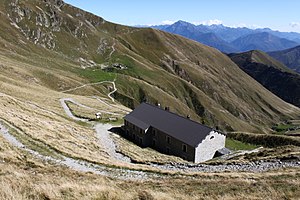
Rifugio San Jorio at the San Jorio Pass |
||
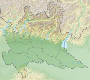
| location | San Jorio Pass ; Como Province , Lombardy , Italy ; Valley location: Gravedona ed Uniti | |
| Mountain range | Como Prealps | |
| Geographical location: | 46 ° 10 '0.2 " N , 9 ° 9' 35.7" E | |
| Altitude | 1980 m slm | |
|
|
||
| owner | Operazione Mato Grosso (OMG) | |
| Construction type | Refuge | |
| Usual opening times | June to September | |
| accommodation | 25 beds, 0 camps | |
| Web link | www.rifugiosjorio.it | |
The Rifugio San Jorio (German San Joriohütte ) is an alpine refuge in the Italian region of Lombardy in the Como Prealps . The name goes back to the hermit San Jorio, to whom the slightly higher chapel is dedicated.
location
It is located directly below the San Jorio Pass , on the border between Italy and Switzerland. The pass connects the upper Lake Como with Bellinzona and Lake Maggiore as well as the Albano and San Jorio valleys with the Morobbiatal in Switzerland.
history
The hut is a former barracks of the Italian financial police , which tried to stem the once heavy smuggling into the nearby canton of Ticino .
The San Jorio Pass has served as a trade route for centuries. The silk made in Como was transported to Germany and the iron material used in the workshops of Dongo to the Morobbiatal.
The hut is run by volunteers from the association “Together for the poor” ( Insieme per i poveri ), similar to an Alpine club hut, from June to September and has 25 beds. This is part of "Operation Mato Grosso ", a movement of volunteers that has been working for the poor in Brazil, Bolivia, Ecuador and Peru free of charge since 1967. The proceeds from the hut management will be donated to this movement.
The hut is an ideal base for cross-border hikes of all levels of difficulty. On a clear day, the view extends from the Swiss Alps to Monte Rosa and the Matterhorn .
Directions
After Chiasso (Switzerland) across the border to Cernobbio (Italy) and now follow Strada Statale 340 (SS 340) to Dongo . Now in a westerly direction via Strada Provinciale 5 (SP 5) to Stazzona , Germasino and Garzeno . Now follow San-Jorio-Straße to the pilgrimage church of the Madonna of Quang / Quansc (parking lot) in front of Brenzeglio.
Accesses
- From Brenzeglio 979 m slm , Italy, 8.1 kilometers in 3 hours, level of difficulty T2.
- From Carena ( Sant'Antonio TI ) 958 m above sea level. M. , Switzerland, in about 3½ hours (T2).
Neighboring huts
- Capanna delle Aguile CAI (bivouac / shelter), 2194 m slm , distance 0.3 km.
- Rifugio Il Giovo CAI (mountain hut), 1706 m slm , 1.7 km.
- Capanna Gesero UTOE FAT (mountain hut), 1765 m above sea level M. , 3.4 km.
- Rifugio Sommafiume CAI (mountain hut), 1784 m slm , 3.7 km.
Web links
- Homepage of the hut (Italian)
- La valle dell`Albano

