Rohrsen (Hameln)
|
Rohrsen
City of Hameln
|
|
|---|---|
| Coordinates: 52 ° 6 ′ 39 ″ N , 9 ° 24 ′ 25 ″ E | |
| Height : | 79 m |
| Area : | 4.1 km² |
| Residents : | 1412 (December 31, 2016) |
| Population density : | 344 inhabitants / km² |
| Incorporation : | February 1, 1923 |
| Postal code : | 31789 |
| Area code : | 05151 |

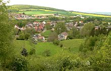
Rohrsen is a district of Hameln ( Lower Saxony ) in the east of the city. The federal road 217 connects the place with the city center. The Hamel flows past the village parallel to the street .
history
Rohrsen was first mentioned in a document in 1237 with the name "Rohrnte" in a list of goods belonging to the Fulda monastery. The name changed in the course of time via "Rorssem", "Roerssen" and "Roersen" to the current name.
The Rohrsen community was incorporated into the city of Hameln on February 1, 1923.
Rohrsen train station
The place had a train station on the Hanover – Altenbeken railway line . Since the place was around twelve kilometers from the Bückeberg , this station was built with two sidings and sidings as part of the expansion work for the Reichserntedankfest in 1935.
After the Second World War , the platforms that were not needed were dismantled and the station was downgraded to a stop. In the spring of 1959 the detention center was abandoned. At the beginning of the 1970s, the block was superfluous and the station building was demolished.
politics
The local representative is Jobst-Werner Brüggemann.
coat of arms
Three reed cobs standing in waves on a white background .
Culture and sights
- The town's chapel is the successor to a previous chapel that was founded in 1353 but then fell into disrepair.
Web links
Individual evidence
- ↑ Martin Weltner: For the Reich farmers' day . In: Lok Magazin . tape 10/2017 . GeraMond Verlag , Munich, p. 92 .
