Rotbach (Dreisam)
| Rotbach | ||
|
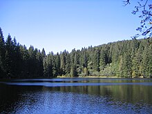
The Rotbach in Hell Valley, also Höllenbach called |
||
| Data | ||
| Water code | DE : 23388 | |
| location | Baden-Wuerttemberg , Germany | |
| River system | Rhine | |
| Drain over | Dreisam → Elz → Rhine → North Sea | |
| source | In Hinterzarten -Oberzarten above the Mathisleweihers 47 ° 53 '7 " N , 8 ° 5' 7" O |
|
| Source height | approx. 1085 m above sea level NN | |
| muzzle | Confluence of the Rotbach and Wagensteigbach to the Dreisam near Kirchzarten Coordinates: 47 ° 58 '27 " N , 7 ° 57' 38" E 47 ° 58 '27 " N , 7 ° 57' 38" E |
|
| Mouth height | approx. 377 m above sea level NN | |
| Height difference | approx. 708 m | |
| Bottom slope | approx. 36 ‰ | |
| length | 19.9 km | |
| Catchment area | 48.6 km² | |
| Reservoirs flowed through | Mathisleweiher | |
| Communities | Hinterzarten , Buchenbach and Kirchzarten | |
The Rotbach (in the upper reaches Zartenbach and Löffeltalbach , in the middle reaches Höllenbach ) is the 19.9 km long, left and southeastern main source river of the Dreisam in the southern Black Forest ( Baden-Württemberg , Germany ).
Zartenbach
The source streams of the upper reaches of the Zartenbach begin in the municipality of Hinterzarten ( Southern Black Forest Nature Park ) southwest of the Oberzarten district in the eastern steep slopes of the Ramselehöhe (1111.9 m) at an altitude of around 1085 meters. They gather at the bottom of a hollow valley formed by ice age glaciers with a stepped longitudinal profile. In one of the evacuations , the brook in the Mathisleweiher ( 999 m above sea level ) is dammed. Then it flows in a wide left curve around the Windeck ( 1209 m ) and flows northwards via Ober- and Hinterzarten into the extensive hollow of the flat Hinterzartener Moor ( nature reserve ).
Löffeltalbach
After the runoff of the western part of the moor has flowed towards it from the west, the brook sinks with a steeply steep slope into a notch valley, which is called the Löffeltal after the companies that used to make wooden spoons here . The Löffeltalsteige , the ascent from Höllental to the height of Hinterzarten , used to run through this valley .
Höllenbach
In Höllental, the Löffeltalbach joins the Ravennabach coming from the northeast from the Ravennaschlucht . Then the stream, now called Höllenbach , flows northwestwards through the straight trough valley of the upper Höllental valley, which is shaped by glaciers, and then a gorge-like section of the valley known as the Hirschsprung or Höllenpass . In Höllental, the stream is accompanied by the B 31 and the Höllentalbahn .
Rotbach
In the lower valley area it flows - henceforth as Rotbach - through Falkensteig and Himmelreich (districts of Buchenbach ), where it emerges into the plain of the Zartener Basin. North of Kirchzarten , the Rotbach joins above the bridge on Landesstraße 127 at 377 m above sea level. NN with the Wagensteigbach to Dreisam .
Worth seeing
Sights on the Rotbach include:
- Mathisleweiher (also called Mathislesweiher or Mathiesleweiher; source pond of the Zartenbach or Rotbach)
- Höllental (narrow valley of Höllenbach / Rotbach)
- Ravennaschlucht with Ravennabach (side valley of Höllental)
- Tarodunum (approx. 200 ha Celtic oppidum ; east of Kirchzarten)

