Roterdspitze
| Roterdspitze | ||
|---|---|---|
|
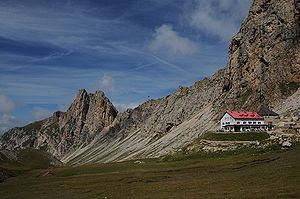
The Roterdspitze (left), right in the foreground the Tierser-Alpl-Hütte |
||
| height | 2655 m slm | |
| location | South Tyrol , Italy | |
| Mountains | Sciliar group , Dolomites | |
| Dominance | 1.54 km → Grasleitenspitzen | |
| Notch height | 211 m ↓ Tierser Alpl | |
| Coordinates | 46 ° 29'53 " N , 11 ° 37'8" E | |
|
|
||
The Roterdspitze ( Italian Cima di Terrarossa ) is at 2655 m slm the highest peak in the Sciliar group in the South Tyrolean Dolomites .
Location and surroundings
The Roterdspitze is located in the south-east of South Tyrol in the Schlern-Rosengarten nature park . The summit area lies in the border area of the municipalities of Castelrotto , Tiers and Völs am Schlern . To the north to the Alpe di Siusi and to the south the mountain structure breaks off with steep flanks. To the west, the summit structure is connected to the Schlern plateau via a gentle saddle . To the east is the sharp ridge of the horse teeth .
Climbs
The summit of the Roterdspitze is easily accessible from the west. An ascent is often combined with an ascent of the Schlern. In addition, the summit is accessible via the Maximilian via ferrata , which begins at the Tierser-Alpl-Hütte to the east and ends at the Roterdspitze after crossing the Rosszähne.
literature
- Hanspaul Menara and Josef Rampold : South Tyrolean mountain tours . Athesia, Bozen 1976, p. 185-186 .

