Transtaïga route
| Transtaïga route | ||||||||||||||||||||||||||||||||||||||||||||||
|---|---|---|---|---|---|---|---|---|---|---|---|---|---|---|---|---|---|---|---|---|---|---|---|---|---|---|---|---|---|---|---|---|---|---|---|---|---|---|---|---|---|---|---|---|---|---|
| map | ||||||||||||||||||||||||||||||||||||||||||||||
| Basic data | ||||||||||||||||||||||||||||||||||||||||||||||
| Operator: | Société de development de la Baie-James | |||||||||||||||||||||||||||||||||||||||||||||
| Start of the street: | 70 km south of Radisson ( 53 ° 19 ′ N , 77 ° 27 ′ W ) |
|||||||||||||||||||||||||||||||||||||||||||||
| End of street: |
Brisay hydropower station ( 54 ° 25 ′ N , 70 ° 29 ′ W ) |
|||||||||||||||||||||||||||||||||||||||||||||
| Overall length: | 582 km | |||||||||||||||||||||||||||||||||||||||||||||
|
Region : |
||||||||||||||||||||||||||||||||||||||||||||||
| Development condition: | Gravel road | |||||||||||||||||||||||||||||||||||||||||||||
| Transtaïga route | ||||||||||||||||||||||||||||||||||||||||||||||
|
Course of the road
|
||||||||||||||||||||||||||||||||||||||||||||||
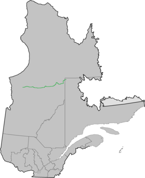
The Transtaïga route is a 582 km (including Chemin Caniapiscau : 666 km) long gravel road in the Canadian province of Québec . It runs in the Jamésie region and connects several hydropower plants in the otherwise unpopulated area.
description
Opened in 1981, the Transtaïga Route was built to serve various remote construction sites of Hydro-Québec's Baie James hydropower project . The northeast end of the road near the 55th parallel north is 745 km from Radisson , making Route Transtaïga the most remote road in North America . Although located Schefferville from the end point of view, just 190 kilometers away, but no connection exists there because the terrain is impassable terrain vehicle itself.
At kilometer 544 of the paved Route de la Baie James , the Transtaïga route branches off to the east and runs near La Grande Rivière and Rivière Caniapiscau . Several outfitters have set up base camps along the road from where hunting and fishing expeditions can be undertaken. Some of them provide fuel, food and accommodation. As the name suggests, the road leads through almost endless boreal coniferous forest (also known as the Russian name Taiga). There are plans to extend the Transtaïga route to Kuujjuaq in the Nunavik region ; this would also open up Schefferville.
Course of the road
| km | Place / facility |
|---|---|
| 0 | The road starts at 544 km on the Route de la Baie James |
| 23 | Emergency phone |
| 56 | Bridge over the Rivière Sakami |
| 62 | Robert-Bourassa Reservoir |
| 96 | La Grande-3 airfield |
| 100 | Access road to the La Grande-3 hydropower plant (28 km north) |
| 203 | Bridge over the Rivière De Pontois |
| 286 | Nouchimi Outfitter base camp (fuel, restaurant, room) |
| 292 | La Grande-4 airfield |
| 307 | Access road to the Hydro Québec settlement of Keyano (1 km south) |
| 311 | Access road to the La Grande-4 hydropower plant (5 km north) |
| 358 | Pont Polaris bridge over La Grande Rivière and Mirage Outfitter base camp (fuel, restaurant, rooms) |
| 395 | Access road to the Laforge-1 hydropower plant (42 km north) |
| 525 | Access road to the Laforge-2 hydropower plant (7 km north) |
| 528 | Laforge-2 airfield |
| 582 | Brisay hydroelectric power station ; From here the road conditions are significantly worse, off-road vehicle recommended |
| 666 | Caniapiscau reservoir and Duplanter flood relief, end of the road |

