Roxburgh (New Zealand)
| Roxburgh | ||
| Geographical location | ||
|
|
||
| Coordinates | 45 ° 32 ′ S , 169 ° 19 ′ E | |
| Region ISO | NZ-OTA | |
| Country |
|
|
| region | Otago | |
| District | Central Otago District | |
| Ward | Roxburgh Ward | |
| Residents | 522 (2013) | |
| height | 94 m | |
| Post Code | 9500 | |
| Telephone code | +64 (0) 3 | |
| UN / LOCODE | NZ RXB | |
| Photography of the place | ||
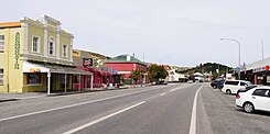
 Scotland Street looking south |
||
Roxburgh is a small town in the Central Otago District of the Otago regionon the South Island of New Zealand .
Origin of name
The place was named after Roxburgh , an old, derelict town on the River Teviot in Scotland .
geography
The place is located about 33 km south-southwest of Alexandra and about 51 km north-northwest of Lawrence in the valley of the Clutha River . About 7 km to the north is the Roxburgh Dam , which was the first dam on the Clutha River that was used to generate electricity. The New Zealand State Highway 8 runs through Roxburgh and connects the town with Alexandra in the north and the eastern parts of the Otago region. A small airfield with a grass runway north of the village allows air traffic with small single-engine aircraft.
history
Roxburgh was important during the Otago gold rush in the 1860s.
From 1928 to 1968 the Roxburgh Branch , a branch line of the Main South Line, ran to Roxburgh . During the entire service life of the line, the railway traffic drove it losses, but helped in the economic development of the place and was also important for the material supply for the construction of the Roxburgh Dam .
Remains of the former railway terminus in Roxburgh , such as the pit of a turntable, a water tank for the supply of steam locomotives and the station building, a barn and a workshop. Most of the houses in which the railway workers once lived, known as " Railway Houses ", are still there today and are privately owned.
population
In the 2013 census, the town had 522 inhabitants, 14.7% fewer than in the 2006 census.
economy
Livestock and fruit growing are the main industries in and around Roxburgh . Large orchards can be found along the Clutha River and directly north on a plain on the opposite side of the river. The region is one of the main areas for growing apples in New Zealand. Cherries , apricots , peaches and plums are also preferred .
Another, but no longer so important, branch of the economy is open-cast lignite mining , which opens up around 1 km west of Roxburgh Dam and the small settlement of Lake Roxburgh Village .
media
The city shots for the film “ When the Sea Disappeared ” (2004) were shot in Roxburgh.
literature
- Helga Neubauer: Roxburgh . In: The New Zealand Book . 1st edition. NZ Visitor Publications , Nelson 2003, ISBN 1-877339-00-8 , pp. 821-823 .
Individual evidence
- ↑ a b 2013 Census QuickStats about a place: Rocburgh . Statistics New Zealand , accessed September 19, 2017 .
- ^ Roxburgh . In: The New Zealand Book . 2003, p. 823 .
- ↑ Topo250 maps . Land Information New Zealand , accessed September 19, 2017 .
- ^ Neubauer: Roxburgh . In: The New Zealand Book . 2003, p. 821 .
- ↑ When the sea disappeared. IMDb.com, Inc , accessed September 19, 2017 .
