
Söllbach (Murr)
| Söllbach | ||
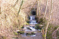
 The Söllbach in the Söllbachklinge |
||
| Data | ||
| Water code | DE : 23838592 | |
| location |
Neckar basin
|
|
| River system | Rhine | |
| Drain over | Murr → Neckar → Rhine → North Sea | |
| source | at the Backnang Stiftsgrundhof near the municipal triangle of Backnang / Burgstetten / Leutenbach 48 ° 54 ′ 39 ″ N , 9 ° 24 ′ 40 ″ E |
|
| Source height | approx. 307 m above sea level NHN | |
| muzzle | approx. 0.8 km northeast of the center of Burgstetten- Burgstall an der Murr from the left and south-southeast in the Murr coordinates: 48 ° 56 '0 " N , 9 ° 22' 50" E 48 ° 56 '0 " N , 9 ° 22 ′ 50 ″ O |
|
| Mouth height | approx. 220 m above sea level NHN | |
| Height difference | approx. 87 m | |
| Bottom slope | approx. 22 ‰ | |
| length | 3.9 km | |
| Catchment area | approx. 4.1 km² | |
The Söllbach is a 4 km long brook in the Rems-Murr district in Baden-Württemberg , which flows north-east of the village of Burgstall an der Murr in the municipality of Burgstetten from the left into the lower Murr .
geography
course
The Söllbach arises near the individual farms of the hamlet of Stiftsgrundhof in the city of Backnang at the municipal triangle of Backnang / Leutenbach / Burgstetten between fields at about 307 m above sea level. NHN . On the first half a kilometer of its course, it flows westward on the municipal boundary between Leutenbach in the south and Burgstetten in the north, then it swings to the right on its then very steady northwest course, which the border continues to roughly follow. It crosses under the K 1846 between the Leutenbach district of Nellmersbach in the south and the Burgstetten district of Erbstetten in the north. In its flat hollow, which will soon be occupied by a meadow, the forest island Brandwald extends from the left hill to close to the left bank. A stream, which is fed by an overflow of a spring catchment and therefore usually has no flow, runs out of the forest, after which the Söllbach flows over to the municipality of Burgstetten.
About 150 meters further down the valley at a widening of the stream bed there is a ponor on the left and right at the edge of the stream , both of which swallow part of the inflowing water. Another 300 meters down, the brook runs piped under the grounds of the Erbstetten outdoor pool. In this section, a mile-long tributary flows from a shallow secondary trough from the east, which arises in the Gewann Blumental and which often runs through a small industrial area and then through the sports facilities in its lower valley basin.
Then the Söllbach passes a pump house on the run and crosses under the K 1906 from Erbstetten on the right upper slope to Burgstall on the left hill and behind it and passes another pump house. After a short twisted section, it appears next to the Erbstetten sewage treatment plant on the right, a little above it, below 260 m above sea level. NHN enters the wooded Söllbachklinge of its steepening lower course, which is now moving ever north. At the end of this gorge valley section, which is just over half a kilometer long, it crosses in an approximately 150 m long passage below an old shell limestone quarry on the right valley spur, the dam of the Kleine Murrbahn, which follows the left edge of the valley of the eponymous river . After the culvert, the stream falls over some cascades of waterfall created during the construction of the railway, the great difference in height from the natural terrain level, which is gained by the almost horizontal guidance of the culvert.
The Söllbach now runs another 200 meters north over the flat floodplain and finally flows about 0.8 km northeast of the center of the village of Burgstall, which descends a little down the valley to the edge of the river, from the left and finally south at 220 m above sea level. NHN into the lower Murr flowing westwards here .
The Söllbach is 3.9 km long and drops by about 87 meters on this route, so its mean slope is about 22 ‰.
Catchment area
The Söllbach has a catchment area of 4.1 km², which extends in a spindle-shaped manner from a hill north of the village of Nellmersbach von Leutenbach about 3.7 km to the mouth northwest of it. Across it, it measures a little less than 1.5 km even at its widest point. Behind the right watershed on the northeast side, after the immediate catchment area of the upward Murr, its slightly longer left tributary Maubach competes , behind the left in the southeast with the Buchenbach its largest ever, the one after its upper parallel section, where it is beyond Nellmersbach the Höllachbach and briefly after that the Lerchengraben still runs, before its mouth there is no longer any significant tributaries from the scabbard. The highest point is in the upper reaches of the southern watershed at about 338.2 m above sea level. NHN between two water reservoirs on the ridge of Bannreisach .
Overall, the catchment area is part of the mostly flat hilly landscape in the sub-area of the Inner Backnanger Bay of the Neckar Basin natural area . The proportion of forest is around 10%, three quarters of which are part of the forest island of Brand on the left slope of the middle course, the rest fills the blade of the lower course from west of Erbstetten to the edge of the Murr-Aue. The open corridor is mostly plowed. If you disregard the sports facilities in the south of the village of Erbstetten, there is no settlement immediately on the run. The catchment area is shared by the town of Backnang , to which, however, only a small area gusset at Stiftsgrundhof on the uppermost right sheath belongs, Leutenbach , which is on the left-hand side of the brook up to the middle course, and above all Burgstetten , whose village Erbstetten right above the Unterlauf including its district from Bach is mostly drained. The village of Burgstall in the municipality is located across from Erbstetten just across the left watershed with a part of the district to the left of the lower reaches.
Tributaries
List of tributaries from the source to the mouth. Length of water, catchment area and altitude according to the corresponding layers on the LUBW online map. Other sources for the information are noted.
Origin of the Söllbach at about 307 m above sea level. NN at the courtyards of the Backnang hamlet Stiftsgrundhof near the municipality triangle Backnang / Burgstetten / Leutenbach. The stream, which initially ran west next to a dirt road, soon swung to a permanent north-west course.
- (Inconsistent inflow from the Hühnerloch ), from the left and southwest to about 297 m above sea level. NN in Gewann Egelsee next to the K 1846 Nellmersbach – Erbstetten, approx. 0.4 km and approx. 0.2 km². Arises at about 305 m above sea level. NN . Almost all of the dirt roads.
- (Inlet), from the left and west from the forest island Brandwald at about 280 m above sea level. NN , 0.1-0.4 km and about 0.1 km². Arises in the fire forest as an overflow from a spring catchment at about 300 m above sea level. NN and is Grenzbach between Leutenbach and Burgstetten.
- Söllbach sinking, about 150 meters after the previous inflow at an altitude of about 278 m above sea level. NN east of the forest island Brandwald .
- (Inflow), from the right and east to over 270 m above sea level. NN at the bath of Erbstetten, approx. 1.1 km and approx. 0.9 km². Arises at about 295 m above sea level. NN in the Erbstettener Blumental and is initially a dirt road.
Mouth of the Söllbach from the left and finally south to about 220 m above sea level. NHN in the lower Murr about 0.8 km northeast of the center of Burgstall. The stream is 3.9 km long and has a catchment area of around 4.1 km².
geology
The Backnang Bay, in which the Söllbach runs, is largely covered by a layer of loess derivatives , the raw material of which was deposited in the Quaternary . The upper Söllbach runs accordingly in this layer, its deeper basin on the middle reaches in the lower Keuper , as does the inlet at Erbstettener Bad. Where the hollow then attaches to its blade section, the bed enters the Upper Muschelkalk . In the left floodplain of the Murr, the Söllbach flows into a flood sediment strip that accompanies the river. On the higher hills on both sides of the course there is partly gypsum keuper ( Grabfeld formation ) in islands , the highest layer in the catchment area.
The aforementioned Söllbach infiltration a little south of the Erbstettener Bad is located in the shallow outcrop of the Unterseuper above the Upper Muschelkalk, which is partly showing karst phenomena in the surrounding area , a very common constellation in the gauze landscapes of the south-west German stepland . The widening of the stream bed at this point could indicate a former sinkhole, which in the meantime has been partially sealed by flooded material, while the two ponors are still connected to the underground fissured aquifer.
Upper Muschelkalk was mined in the abandoned quarry on the right slope above the lower Söllbachklinge.
gallery

The Söllbachklinge, just before the passage under the railway line

The passage of the Söllbach under the railway line
The Söllbach between the passage under the railway line and the confluence with the Murr


Individual evidence
- ↑ a b c Height according to the contour line image on the background layer Topographic map from the online map server of the State Institute for the Environment, Measurements and Nature Conservation Baden-Württemberg (LUBW). See the → web links .
- ↑ a b c Length according to the water network layer ( AWGN ) of the LUBW's online map server.
- ↑ a b Catchment area measured on the background layer topographic map of the LUBW's online map server.
- ↑ Natural space according to Hansjörg Dongus : Geographical land survey: The natural space units on sheet 171 Göppingen. Federal Institute for Regional Studies, Bad Godesberg 1961. → Online map (PDF; 4.3 MB)
- ↑ a b c Length measured on the background layer Topographic map of the LUBW's online map server.
- ↑ Geology according to the geological map mentioned under → Literature , which, however, no longer shows the upper course above the inlet from the Hühnerklinge , and according to the only coarser-resolution online map server of the State Office for Geology, Raw Materials and Mining (LGRB), see the → Web links .
- ^ Geotope profile Söllbachversinkung (PDF, 992 kByte) at LGRB.
- ↑ Geotope profile quarry west of Erbstetten (PDF, 340 kByte) at LGRB.
literature
- Topographic map 1: 25,000 Baden-Württemberg, as single sheet No. 7022 Backnang
- Geological map of the Swabian-Franconian Forest Nature Park 1: 50,000, published by the State Office for Geology, Raw Materials and Mining Baden-Württemberg, Freiburg i. Br. 2001.
Web links
- Course and catchment area of the Söllbach on: State Institute for the Environment Baden-Württemberg (LUBW) ( information )
- Course and catchment area of the Söllbach on: Geoportal Baden-Württemberg ( information )
- Map server of the State Office for Geology, Raw Materials and Mining (LGRB) ( information )