
Maubach (Murr)
| Maubach | ||
 Infiltration stretch of the Maubach on the lower reaches |
||
| Data | ||
| Water code | DE : 23838552 | |
| location |
Neckar basin
|
|
| River system | Rhine | |
| Drain over | Murr → Neckar → Rhine → North Sea | |
| source | southwest of Backnang- Waldrems on the B 14 48 ° 54 ′ 24 ″ N , 9 ° 25 ′ 22 ″ E |
|
| Source height | approx. 305 m above sea level NN | |
| muzzle | below Backnang in front of the sewage treatment plant near Neuschöntal from the left and south-southeast into the lower Murr Coordinates: 48 ° 56 '10 " N , 9 ° 24' 14" E 48 ° 56 '10 " N , 9 ° 24' 14" E |
|
| Mouth height | approx. 229.3 m above sea level NN | |
| Height difference | approx. 75.7 m | |
| Bottom slope | approx. 14 ‰ | |
| length | 5.6 km | |
| Catchment area | 10.5 km² | |
The Maubach is a 5 km long stream in the Rems-Murr district in Baden-Württemberg , which flows into the Murr from the left and south-southeast at the boundary of the city of Backnang to the municipality of Burgstetten towards the end of the middle course .
geography
course
The Untermaubach arises in the Backnanger Bay against its southern border to the foothills of the in the southeast near the adjacent natural area of Berglen between the Leutenbacher suburb Nellmersbach in the southwest and the Backnanger district Waldrems in the northeast. Its source is on the B 14 between the two places close to the tree line of the Rotenbühl . In the Gewann Eichwald it rises at about 305 m above sea level. NN in a seepage spring in a swamp forest with black alder , ash and white willow and flows off in a moat accompanied by a riparian forest gallery.
For the first half a kilometer of its course, the brook runs northwards through meadows and fields occupied by small-scale meadows and fields to the edge of the rock that accompanies the embankment of the Murrtalbahn . After changing through a passage to the west side of the railway embankment, the first tributary to Weihergraben flows underground from the left under a large field at the Backnang hamlet of Stiftsgrundhof ; in terms of length and catchment area, an at least equivalent left upper course, the one in front of its rotten stretch between two separate ones Groups of houses in the hamlet run through a 0.2 hectare pond on the roadside. Now the stream continues in a narrow strip of grass next to the embankment in the same direction until it turns to the northeast about a kilometer below its origin and switches back to the other side of the railway line through a passage accompanied by a walkway.
Beyond that, it soon runs underground through the Waldremser industrial zone around Donaustraße. At the next crossing under the B 14, which separates the commercial and residential zones of the village, it comes out again and continues on the western edge of the settlement. Already at the beginning opens here the first right inflow Aubach whose more significant left upper reaches Fischbach on the northern edge of the Rotenbühls created and more, on whose crest resulting small pretty up sounding drained. In the area of the outskirts there is another tributary, the Langenbach through the village from the south-east, then the stream meanders close to nature in a riparian forest belt, mostly very flat through the meadow softness of the place to the old school, after which it pulls straightened between its bank trees .
For the most part already in the district of Heiningen , the Reisbach then flows from the east to about 279 m above sea level. NN to. Here the Maubach bends to the northwest, between rather bare banks it now runs in a sunk ditch towards Maubach , whose settlement zone it reaches after crossing the B 14 again. Straight as a dead line, but again between more dense trees, it runs between the old town center on the right and high blocks of flats on the left, opposite which the Entenbach flows from the right . With a length of 1.7 km and a catchment area of around 1.9 km², its largest tributary, the The southern edge of the commercial zone of the city of Backnang itself around Heinrich-Hertz-Strasse begins its rather bare course.
In the village of Maubach the stream crosses under the railway line again together with the K 1906, on the other side it reaches the edge of the birch forest on the left slope of the now deeper valley just before the bridge of the road to Erbstetten . From the southern part of Bachrain , a near-natural, only temporarily water-bearing brook runs to the northeast. At about this height, the stream drains away and only comes back to light after about 1.6 km at the level of the railway bridge, shortly before its mouth. Only after extreme rainfall does the Maubach carry significant amounts of water on this section, but even then no continuous watercourse can be observed. A little north-west of the bridge on the outskirts, a shell limestone quarry was formerly operated in the hollow that changes to the blade here, which later served as a garbage dump and is now filled. Below the stream bed meanders freely on the bottom of the meandering narrow valley floor and touches steep slopes, on which the rock rises up to twice a man's height. Its bed, up to five meters wide, lies on banks of shell limestone or over stone gravel, fords cross it in two places. The small floodplains alternate with black alder and ash forest, which sometimes also accompanies the stream as a gallery. The so-called robber's cave is located on the right steep slope , it shows the karstification of the lower Maubach catchment area as well as the numerous sinkholes on the slope to the edge heights, some of which are grouped into rows of sinkholes.
Shortly before its confluence, the Maubach emerges again and crosses under the bridge of the Backnang – Ludwigsburg railway line . Then the stream enters the Murrtalaue under the road from Backnang to Erbstetten (K 1897) and finally flows after a total of 5.6 km at about 229 m above sea level. NN from the left at the end of the middle course of the Murr from the left into the river, a few meters from the sewage treatment plant on the opposite bank. It has a bottom slope of about 76 m in absolute terms, relative to about 13 ‰.
Catchment area
The Maubach drains 10.5 km² of the Backnang Bay northwards to its central body of water, the Murr. Its catchment area borders in the north of the Murr itself drained area, in the east the catchment area of the Weißach running to the upward Murr , the Weißach tributary Horbach and some higher brooks in the Weißach brook system. In the south, the watershed runs first on the ridge of the forest ridge of the Rotenbühl towards Hertmannsweiler Bach and Rotbach , then on the range of hills north of Nellmersbach towards its village waters of Höllachbach , all of which are tributary to the downward Murr tributary of Buchenbach . In the west, the drainage area of the closer competitor Söllbach pushes in front of it, which runs in a similar direction before the downward Murr.
The highest point in the catchment area is in Rotenbühl at 408.5 m above sea level. NN . Besides there, there is also a forest in the birch forest on both sides of the underflow ridge, both parts of the area remaining under one square kilometer each. The remainder of the corridor is mostly plowed, except in locations near the valley. The settlement and commercial areas of the large villages of Waldrems, Heiningen and Maubach as well as of Backnang itself, to which they all belong, are also not inconsiderable. In addition to these, there are only the Stiftsgrundhof settlement areas in the catchment area, he is the only one to the left of the course, and Germannsweiler to the right above the lowest course, both are also districts of Backnang. To Burgstetten a completely free settlement eighth of the catchment area belongs to its western edge downhill from the last-mentioned inflow from the Bachrain in from the left watershed to the stream.
Tributaries
Including the Maubach itself and a 2nd order tributary .
| Stat. [m] |
GKZ | Surname | from | Length [km] |
EZG [km²] |
Mouth | Mouth height [m above sea level NN ] |
Source location | Source height [m above sea level NN] |
comment |
|---|---|---|---|---|---|---|---|---|---|---|
| n / A | 23838552 | Maubach | n / A | 5.6 | 10.5 | Backnang - Neuschöntal , opposite. | 229.3 | Backnang- Waldrems , Eichwald | 305 | |
| 4,926 | 23838552-12 | Weihergraben | Left | 0.5 | 0.4 | Backnang- Stiftsgrundhof , on the railway line | 291 | Backnang-Stiftsgrundhof | 305 | Runs through at approx. 298 m above sea level. NN a pond of 0.2 ha |
| 3,888 | 23838552-2 | Aubach | right | 0.8 | 1.5 | Backnang-Waldrems, on B 14 | 283 | Backnang-Waldrems, southern edge | 295 | |
| 127 | 23838552-22 | Fischbach | Left | 0.9 | 1.0 | Backnang-Waldrems, southern edge | 284 | Backnang-Waldrems, the edge of the forest in Rotenbühl / Eichwald | 298 | more important branch of the Aubach |
| 3,682 | 23838552-4 | Langenbach | right | 1.1 | 0.6 | Backnang-Waldrems, western edge | 282 | Backnang-Waldrems, eastern edge | 300 | |
| 3,303 | 23838552-6 | Reisbach | right | 1.3 | 1.3 | Backnang-Waldrems against Backnang- Untermaubach to | 279 | Backnang- Heiningen , in the east before the landing site | 291 | Here north-west bend in the direction of the feed of the Reisbach |
| 2,756 | 23838552-8 | Duck stream | right | 1.7 | 1.9 | Backnang- Maubach , Klagenfurter Strasse | 277 | Backnang, southern edge in Grund | 296 | |
| 1,966 | 23838552-9? | (Intermittent inflow from Bachrain forest ) | Left | 1 | 0.6 | Backnang-Maubach, western edge in front of bridge K 1906 | 272 | Backnang-Maubach, southern Bachrain | 300 | Stationing interpolated, valid GKZ prefix up to “?” Developed. Grenzbach Backnang-Maubach / Burgstetten- Erbstetten |
- ↑ Stationing, the distance from the Maubach estuary up to this tributary.
- ↑ Water code number , in Germany the official river code number . After the prefix common to all tributaries, which stands for the Maubach itself, a separator has been inserted for better readability.
geology
The highest geological layer in the Keuper package of the catchment area is a wide strip of reed sandstone ( Stuttgart Formation ) alternating with Lower Colorful Marls ( Steigerwald Formation ) on the Rotenbühl , under which the small clay blades of the Fichtenbach cave in. The origin of the brook itself lies in the area of a tongue of Gipskeupers ( Grabfeld formation ) that protrudes from a mountain ledge to the northwest . From about the bend in the run to the northwest between Waldrems and Maubach, the Unterkeuper begins , in the local area of Maubach the Upper Muschelkalk , below the former quarry with the Trigonodus dolomite ( Rottweil formation ). Over the larger part of the catchment area, the Mesozoic layers are covered by the loess sediment typical of the Backnang Bay , which emerged from the Aeolian deposits of the Quaternary .
The Maubach is known for the karstification on its lower course in the shell limestone, which is most evident in its own seepage after leaving Maubach. Below Maubach there are also many sinkholes on both sides of the slopes, including a 700-meter-long row of sinkholes that starts on the left slope on the Maubach – Erbstetten road and follows the smear line from Unterkeuper / Oberer Muschelkalk to the northwest. Further to the northwest it has another sequel. The so-called robber cave has already been mentioned .
gallery
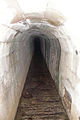
First passage of the Maubach under the railway line

Maubach infiltration near the limestone quarry
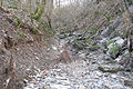
Maubach infiltration after the limestone quarry

Maubach seepage after heavy rainfall

Maubach infiltration shortly before the robber cave

The robber's den near the mouth


Individual evidence
- ↑ a b c d e f g h i j k l m n o p q Height according to the contour line image on the background layer Topographic map of the online map server of the State Institute for the Environment, Measurements and Nature Conservation Baden-Württemberg (LUBW). See the → web links .
- ↑ a b Height according to the blue lettering on the background layer Topographic map of the LUBW's online map server.
- ↑ a b c d e f g h Length according to the water network layer ( AWGN ) of the LUBW's online map server.
- ↑ a b Catchment area according to the basic catchment area (AWGN) layer of the LUBW's online map server.
- ↑ a b c d e f g Catchment area measured on the background layer of the topographic map of the LUBW's online map server.
- ↑ Lake area according to the layer standing waters of the LUBW's online map server.
- ↑ Length measured on the background layer of the topographic map of the LUBW's online map server.
- ↑ Geology according to the geological map mentioned in → literature . In a poorer resolution also on the online map server of the State Office for Geology, Raw Materials and Mining (LGRB), see the → web links .
- ↑ Sinking holes in the birch forest east of Erbstetten , geotope description of the State Office for Geology, Raw Materials and Mining Baden-Württemberg (PDF, 328 kByte).
- ↑ Sinking holes in the Schafrain in the Gewann Weihersbrunnen east-northeast of Erbstetten , geotope description of the State Office for Geology, Raw Materials and Mining Baden-Württemberg (PDF, 339 kByte).
- ↑ Description of the "Räuberhöhle" (PDF, 771 kByte) on the Arge Grabenstetten website.
literature
- Topographic map 1: 25,000 Baden-Württemberg, as single sheet No. 7022 Backnang
- Geological map of the Swabian-Franconian Forest Nature Park 1: 50,000, published by the State Office for Geology, Raw Materials and Mining Baden-Württemberg, Freiburg i. Br. 2001.