
Sabon Birni (Niger)
Location of Sabon Birni in Niger |

Sabon Birni is a village in the rural municipality of Tounouga in Niger .
The village, led by a traditional chief (chef traditionnel) , is located about nine kilometers northwest of Tounouga, the capital of the rural community of the same name, which belongs to the Gaya department in the Dosso region. Almost three kilometers east of Sabon Birni, across the large dry valley Dallol Foga , there is a border crossing to Nigeria . On the other side of the border is the city of Kamba . Other larger settlements in the vicinity of Sabon Birni are the village of Bengou in the north, around ten kilometers away, and the town of Gaya in the west, around twelve kilometers away . The village is part of the 317,520 hectare wetland of the Dallol Maouri , which is protected under the Ramsar Convention .
The place name comes from the Hausa language and means "new city".
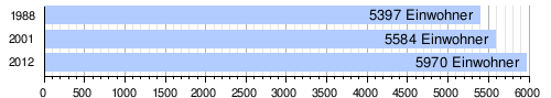
At the 2012 census, Sabon Birni had 5970 residents living in 858 households. At the 2001 census, the population was 5,584 in 715 households, and at the 1988 census, the population was 5,397 in 698 households.
The market day in Sabon Birni is Wednesday. Because of the strong presence of the Nigerien customs authority in Sabon Birni, only a few merchants from Nigeria sell their goods in the market in the village, which is consequently underdeveloped. Instead, local producers go to Gaya, Malanville , Kamba and the Marché de Katako in the capital Niamey to sell their produce .
Individual evidence
- ↑ a b National Repertoire des Localités (ReNaLoc). (RAR; 11.3 MB) Institut National de la Statistique de la République du Niger, July 2014, p. 165 , accessed on August 7, 2015 (French).
- ↑ Dallol Maouri. In: Ramsar Sites Information Service. April 13, 2018, accessed April 2, 2019 .
- ↑ Anthony Kirk-Greene: The meaning of place names in Hausaland . In: Bulletin de l'Institut Fondamental d'Afrique Noire . Tome 31, no. 1 , 1969, p. 269 .
- ^ Répertoire National des Communes (RENACOM). (RAR file; 1.5 MB) Institut National de la Statistique, accessed on November 8, 2010 (French).
- ↑ Recensement Général de la Population 1988: Répertoire National des Villages du Niger . Bureau Central de Recensement, Ministère du Plan, République du Niger, Niamey March 1991, p. 107 ( ceped.org [PDF; 14.8 MB ; accessed on January 31, 2018]). www.ceped.org ( Memento of the original dated January 31, 2018 in the Internet Archive ) Info: The archive link was inserted automatically and has not yet been checked. Please check the original and archive link according to the instructions and then remove this notice.
- ↑ Olivier Walther: Affaires de patrons. Villes et commerce transfrontalier au Sahel . Peter Lang, Bern 2008, ISBN 978-3-03911-468-9 , pp. 183 and 193 .
Coordinates: 11 ° 53 ' N , 3 ° 36' E