
Saint-Lambert (Montérégie)
| Saint-Lambert | |||
|---|---|---|---|
 City center of Saint-Lambert |
|||
| Location in Quebec | |||
|
|||
| State : |
|
||
| Province : | Quebec | ||
| Administrative region : | Montérégie | ||
| MRC or equivalent : | Longueuil | ||
| Coordinates : | 45 ° 30 ′ N , 73 ° 30 ′ W | ||
| Height : | 12 m | ||
| Area : | 7.55 km² | ||
| Residents : | 21,555 (as of 2011) | ||
| Population density : | 2,855 inhabitants / km² | ||
| Time zone : | Eastern Time ( UTC − 5 ) | ||
| Municipality number: | 58012 | ||
| Postal code : | J4P-J4R | ||
| Area code : | +1 450 | ||
| Mayor : | Alain Dépatie | ||
| Website : | www.ville.saint-lambert.qc.ca | ||
 Located in the Longueuil agglomeration |
|||

Saint-Lambert is a city in the southwest of the Canadian province of Quebec . It is located in the Montérégie administrative region , about five kilometers east of central Montreal . The city is part of the Longueuil agglomeration , has an area of 7.55 km² and has a population of 21,555 (2011). From 2002 to 2006, Saint-Lambert was a district of Longueuil .
geography
Saint-Lambert is located on the east bank of the St. Lawrence River in the Rive-Sud region , in largely flat terrain. A three-kilometer section of the St. Lawrence Seaway runs through the city . Neighboring communities are Longueuil in the north and east, Brossard in the south and Montreal in the west (on the opposite bank of the river).
history

The present-day urban area once belonged to two different manors in New France : on the one hand to the Seigneurie La Prairie, which was transferred to the Jesuits in 1647 , and on the other to the Seigneurie Longueuil, which came into the possession of Charles Le Moyne in 1657 . Settlement began in the early 19th century and agriculture was predominant until the early 1850s. That changed in 1852 when the Champlain and St. Lawrence Railroad (Canada's first railroad line) was extended from La Prairie here. This enabled a more direct ferry connection to Montreal and resulted in rapid urbanization.
The municipality of Saint-Lambert was founded in 1857. The place name is ambiguous: it reminded the English-speaking Protestant of Franz Lambert of Avignon , and the French-speaking Catholic of Lambert Closse , the first commander of the Montreal city militia. In 1859 the Pont Victoria was opened, the first bridge over the St. Lawrence River. This led to a strong population growth, so that the municipality received city status in 1921. 1969 Préville was incorporated. Saint-Lambert was a preferred place of residence for middle-class, English-speaking Protestants for over a century. In 1981, Anglophones still made up 61% of the population. In the following years, more and more Francophones moved to the city, which today make up the vast majority.
The government of the province of Québec ordered the merger of several municipalities with the city of Longueuil , which came into effect on January 1, 2002. Saint-Bruno-de-Montarville now formed a district of Longueuil. This approach met with great resistance in parts of the population. In a referendum on January 20, 2004, 60% of the voters spoke out in favor of the separation. The community was re-established on January 1, 2006, but had to cede some competencies to the community association of the agglomeration Longueuil . Saint-Lambert is a member of the Communauté métropolitaine de Montréal association founded in 2000 .
population
According to the 2011 census, Saint-Lambert had 21,555 inhabitants, which corresponds to a population density of 2855 inh / km². 74.6% of the population stated French as their main language, the share of English was 13.5%. 1.6% said they were bilingual (French and English), other languages and multiple answers accounted for 10.3% (including 2.0% Spanish ). Only French spoke 21.9%. In 2001, 76.0% of the population were Roman Catholic , 9.5% Protestant and 9.6% of no religious denomination.
traffic
The Pont Victoria is a combined road and rail bridge over the Saint Lawrence Seaway and Saint Lawrence River, which connects Saint-Lambert with Montreal. At the same time, a bridge for pedestrians and cyclists leads over the canal to the southern tip of the Île Notre-Dame . Autoroute 20 , one of the most important highways in the province of Québec, runs along the canal bank . This intersects with Route 112 , the main road towards Sherbrooke, which runs over the stream . Saint-Lambert has a train station with AMT local trains between Montreal and Mont-Saint-Hilaire , VIA Rail express trains between Montreal and Québec , Gaspé and Halifax , and Amtrak tourist trains between Montreal and New York City . The city is served by several bus routes operated by the Réseau de transport de Longueuil company . From 1909 to 1956, the Montreal and Southern Counties Railway also ran through Saint-Lambert.
photos

Canal lock
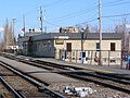
Saint-Lambert train station

Maison Marsil

Pont Victoria


Web links
- Official website of Saint-Lambert (French)
Individual evidence
- ↑ a b Portrait et historique. (No longer available online.) City of Saint-Lambert, formerly the original ; Retrieved January 15, 2014 (French). ( Page no longer available , search in web archives ) Info: The link was automatically marked as defective. Please check the link according to the instructions and then remove this notice.
- ↑ Saint-Lambert. Commission de toponymie du Québec, accessed January 15, 2014 (French).
- ↑ Les paroisses au XIX siècle. Société historique et culturelle du Marigot, accessed January 15, 2014 (French).
- ↑ Référendums du 20 juin 2004. Directeur général des élections du Québec, accessed on January 15, 2014 (French).
- ^ Population profile of the commune of Saint-Lambert. In: 2011 Census. Statistics Canada , 2011, accessed January 15, 2014 (French).
- ^ Population profile of the commune of Saint-Lambert. In: 2001 Census. Statistics Canada , 2001, accessed January 15, 2014 (French).