Saint Marys River (Huron Sea)
|
Saint Marys River St. Marys River, Rivière Ste-Marie |
||
|
View of the Sault Ste. Marie International Bridge , the Canadian bank on the left |
||
| Data | ||
| Water code | US : 1623189 | |
| location | Ontario (Canada), Michigan (USA) border |
|
| River system | Saint Lawrence River | |
| Drain over | St. Clair River → Detroit River → Niagara River → Saint Lawrence River → Atlantic Ocean | |
| origin |
Lake Superior 46 ° 30 ′ 2 ″ N , 84 ° 36 ′ 14 ″ W. |
|
| Source height | 184 m | |
| muzzle |
North Channel (Huron Sea) Coordinates: 46 ° 3 ′ 20 " N , 83 ° 54 ′ 34" W 46 ° 3 ′ 20 " N , 83 ° 54 ′ 34" W. |
|
| Mouth height | 176 m | |
| Height difference | 8 m | |
| Bottom slope | 0.07 ‰ | |
| length | 120 km | |
| Drain |
MQ |
2135 m³ / s |
| Left tributaries | Garden River , Bar River , Root River | |
| Medium-sized cities | Sault Ste. Marie (Ontario) | |
| Small towns | Sault Ste. Marie (Michigan) | |
|
Rapids on the Saint Marys River |
||
|
Saint Marys River in winter |
||
The Saint Marys River ( US designation) (official name in Canada : English St. Marys River ; French Rivière Ste-Marie ) is a river that over its entire length the border between the US state of Michigan and that in southern Canada Province of Ontario forms.
Course and geography
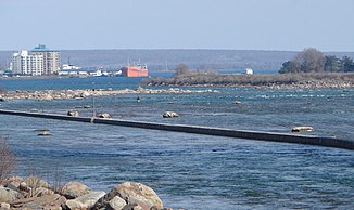
The Saint Marys River forms the outflow of Lake Superior , the largest of the five Great Lakes in North America . The river leaves the lake at the end of Whitefish Bay and flows about 120 km in a south-easterly direction to Lake Huron at a gradient of almost 8 m.
Rapids (called Sault Sainte Marie in French ) lie on the Saint Marys River at the outflow from Lake Superior . Further downstream at the twin towns of Sault Ste. Marie (Ontario) and Sault Ste. Marie, Michigan is where the Soo Locks are located .
Major tributaries of the Saint Marys River on the Ontario side are the Garden River and the Bar River . Other Canadian tributaries include: Fort Creek, Root River , Little Carp River, Big Carp River, Lower Echo River, Desbarats River, and the Two Tree River. American tributaries are: Gogomain River, Munuscong River, Little Munuscong River, Waishkey River, and the Charlotte River.
In the river are the following islands: Drummond Island , St. Joseph Island , Whitefish Island , Sugar Island and Neebish Island .
history
Before the Europeans reached the Saint Marys River, the indigenous people used the river for fishing and trading. The French explorer Étienne Brûlé was the first European to explore the rapids around 1621. In 1641 the Jesuit priests Isaac Jogues and Charles Raymbault followed him and met the Ojibway there . They named the rapids Sault Ste. Marie ( sault means "rapids" in Old French ).
Fort St. Joseph was established on the Canadian bank in 1796 to protect the trading post and ensure British influence in the region. The fort served this purpose during the British-American War of 1812.
The first modern lock, known as the American Lock , was completed in May 1855 by Erastus Corning 's St. Mary's Falls Ship Canal Company . Today there are four parallel locks on the US side of the river, but only two of them are in permanent operation. The Soo Locks lock system became part of the Great Lakes Waterway system in 1959 .
Competitive pressure led to the fact that in 1895 a lock, the Canadian Lock on Sault Ste. Marie Canal , was built. Today this is only used by leisure boats.
bridges
The Sault Ste. Marie International Bridge , a truss arch bridge, directs road traffic across the river. To the west of it the Sault Ste. Marie International Railroad Bridge , a single track railway bridge, over the Saint Marys River.
Web links
- Canadian Heritage web site for St. Marys River
- great-lakes.net Real time Water levels on St. Marys River (with map)
Individual evidence
- ↑ Historic Connecting Channel Outflows ( Memento of the original from July 18, 2011 in the Internet Archive ) Info: The archive link was inserted automatically and has not yet been checked. Please check the original and archive link according to the instructions and then remove this notice. , US Army Corps of Engineers, Detroit District
- ↑ Saint Marys River in the Geographic Names Information System of the United States Geological Survey
- ^ Natural Resources Canada: St. Marys River
- ↑ Great Lakes Atlas: Factsheet # 1. United States Environmental Protection Agency, March 9, 2006, accessed December 3, 2007 .


