Saleskbach
| Saleskbach | ||
|
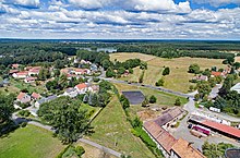
The Saleskbach am Wiesenweg in Grüngräbchen |
||
| Data | ||
| Water code | DE : 538182 | |
| location | West Lusatia , Saxony | |
| River system | Elbe | |
| Drain over | Ruhlander Schwarzwasser → Black Elster → Elbe → North Sea | |
| source | southeast of Cunnersdorf 51 ° 18 ′ 37 ″ N , 14 ° 3 ′ 43 ″ E |
|
| Source height | 167 m above sea level NN | |
| muzzle | northwest of Cosel in the Ruhlander Schwarzwasser Coordinates: 51 ° 22 ′ 59 " N , 13 ° 55 ′ 2" E 51 ° 22 ′ 59 " N , 13 ° 55 ′ 2" E |
|
| Mouth height | 121 m above sea level NN | |
| Height difference | 46 m | |
| Bottom slope | 2.8 ‰ | |
| length | 16.5 km | |
| Left tributaries | Schönbach , Wasserstrich | |
| Communities | Kamenz , Bernsdorf , Schwepnitz | |
The Saleskbach is a left tributary and the most important tributary of the Ruhlander Schwarzwassers in western Lusatia in Saxony . It flows with a slight gradient through the pond area of the Königsbrücker Heideland.
The name is of Sorbian origin and means "behind the wood " ( za lěsk (om) ).
course
The brook rises southeast of Cunnersdorf on the Lausitzer Platte. On its upper course leading to the north, it flows through Cunnersdorf, then feeds the Großer Mühlteich and flows west past Hausdorf .
At the large pond near Straßgräbchen , the stream takes a north-westerly direction. Below that, part of its water is discharged into the large pond at Großgrabe . Then the brook flows through Großgrabe on its middle course, taking in the Schönbach and is crossed by the federal road 97 . At the western exit of Großgrabe the Saleskbach flood is diverted on the right and led around the long pond to the east. The Saleskbach itself flows around the Lange Teich in the south and west, while the brook flows past the Großer Lugteich and the Schwanenteich. At the height of the Forstmühle, opposite the Schwanenteich, the Saleskbach flood flows in again, before part of its water is drained into the new ditch to the Lugteich near Grüngräbchen.
On its lower course, the Saleskbach flows through the northern part of Grüngräbchen , where the water stream joins from the south . South of the Olgahöhe ( 147 m ) are the New Pond, the Nymph Pond and the Crab Pond on the Saleskbach. On its last section, the stream flows through the village of Cosel . To the northwest of Cosel, after 16.5 km near the Saxon-Brandenburg state border, it flows into the Ruhlander Schwarzwasser .
history

The water power of the creek was previously used to operate several water mills. The Bollbuckmühle has been preserved in Cosel.
A large number of fish ponds were created in the wide, swampy floodplains of the Saleskbach.
natural reserve
Parts of the stream belong to the European bird sanctuary ponds northwest of Kamenz . A sub-area comprises the "Großer Teich" east of Großgrabe and the adjacent areas to the northeast between the district road K 9226 and the Saleskbach; another the pond group "Nymphenteich", "Neuteich", "Schlossteich", "Mittelteich" and "Lugteich" as well as the adjoining wet areas at Grüngräbchen. It also includes the pond group "Kaschligteich", "Großteich", "Walschkenteich", "Jungfrauenteich" and "Herrenteich" as well as the surrounding areas located to the south and southwest of Cosel. The stream is part of the habitat of the beaver and the kingfisher . In the Saleskbach lowlands below Grüngräbchen, a small population of mud whiskers was found .
Tributaries
- Cunnersdorfer Bach (l)
- Hausdorfer Bach (r)
- Wuitzschkengraben (l)
- Wutschkenwiesengraben (r)
- Schönbach (l)
- Saleskbach flood (r)
- Winkelwiesengraben (l)
- Water stroke (l)
- Neugraben (r)
- Grüngräbchener Graben (l)
- Triemiggraben (l)
- Walschkengraben (l)
Web links
swell
- ↑ Writings of the Institute for Inland Fisheries e. V. Potsdam - Sacrow: The reintroduction of salmon and sea trout in Brandenburg - Vol. 49 (2017)
- ↑ Ordinance of the Dresden regional council to determine the European bird sanctuary "Teiche northwest Kamenz" v. October 19, 2006
- ↑ In the heart of Brandenburg's Upper Lusatia
- ↑ Short version of the MaP for the SCI 049 and SPA 035 "Königsbrücker Heide"
- Hydrological manual. (PDF; 115 kB) Part 2 - Area Codes. Free State of Saxony - State Office for Environment and Geology, p. 9 , accessed on December 25, 2017 .

