Cosel (Schwepnitz)
|
Cosel
Schwepnitz municipality
Coordinates: 51 ° 22 ′ 41 ″ N , 13 ° 56 ′ 17 ″ E
|
|
|---|---|
| Height : | 124 m above sea level NHN |
| Area : | 11.91 km² |
| Residents : | 159 (2012) |
| Population density : | 13 inhabitants / km² |
| Incorporation : | 1st January 1969 |
| Incorporated into: | Cosel-Zeisholz |
| Postal code : | 01936 |
| Area code : | 035797 |
Cosel ( Upper Sorbian Kózły ) is a district of the municipality of Schwepnitz in the Free State of Saxony . The village is located in the northwest of the Bautzen district on the state border with Brandenburg .
geography
location
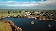
Cosel is ten kilometers south-east of Ruhland in the middle of the Königsbrück-Ruhlander Heiden . The court village with Gelängeflur is from Saleskbach traversed, opens into the at the southern end of Triemiggraben. Cosel is surrounded by a large number of old fish ponds in the south and west. To the south a pond cascade extends along the Triemiggraben (Jungfrauenteich, Herrenteich, Juhrenteich, Wehrigteich), which continues outside the boundary over the Großer Triemigteich to the Schwepnitzer ponds. To the southwest and west of the village is the pond area fed by the Walschkengraben (Walschkenteich, Hofackerteiche, Großteich, Kaschligteich).
Cosel is located in a flat landscape from which the Cosel gravel ridge slightly rises to the east. The highest point of the ridge is the Fuchsberg with the Olgahöhe ( 147 m ). The Otterschützer Heide extends to the south on the site of the former Königsbrück military training area . Today it is part of the Königsbrücker Heide nature reserve . The Ruhlander Schwarzwasser flowing north of Cosel forms the state border with Brandenburg, and the Grünewalder Heide extends over Brandenburg. To the east, Cosel is surrounded by the Dubraukenwald.
Neighboring places
| Jannowitz , Lipsa | Guteborn | Hohenbocka , Grünewald , Sella |
| Kroppen , Zeisholz |

|
Wiednitz , Bernsdorf |
| ( Zochau ) †, ( Otterschütz ) † | Schwepnitz | Grüngraben |
history
On the trade route leading from the Saxon - Bohemian border and customs station Ruhland through the heath to Kamenz , there was already a permanent house , called the Kosela , in the 14th century . After a gentleman from Ileburg auf Ruhland had levied 100 shock tax from the city of Zittau in 1363 , the Bohemian King Charles IV bought the Rulant (Kaupenburg) house from him. A little later, the Lord of Crynitz complained to the liege lord of the Lausitz , Margrave Jobst of Moravia , that the Lord of Ileburg had taken the Kosela from him. After unsuccessful requests for return, Jobst asked the Upper Lusatian estates for assistance in 1405, which the Kosela eventually acquired for a cash payment. The first written mention of the place comes from the year 1406, when the Six Cities Association burned down the Kosela so that it would not get back into dangerous hands.
From 1438 the lords of Taubenheim owned the Cosel manor, initially as an afterlehn of the lords of Kamenz. After 1455 they sold Cosel and the neighboring Sella to the Augustinian monastery in Altendresden . It is believed that the Augustinians built a wooden path or pilgrimage chapel in Cosel, which also housed a cemetery for foreign travelers. The Gothic carved figures of St. Nicholas in the bishop's robe and St. Margarethe with a steeple in the arm and the altar came from the period around 1520. The Governor of the Oberlausitz Karl von Münsterberg withdrew to the monastery both goods under the pretext denied Türkensteuer and sold them on Sunday after Jacobi 1523 4500 Mark his brother Wenzel von Schönburg ( † 1523) on Hoyerswerda for his underage sons Wanke and Georg. After a complaint by the Augustinians to King Ludwig II because of the injustice that had happened to them, the new guardian, Karl von Schönburg zu Pirstein and Trautenau , had to buy both villages from the monastery again for 3,000 florins. After they reached the age of majority, Wanke and Georg, who as bastards were not entitled to use the name “von Schönburg”, named themselves after their Kosel estate as “von der Kosel” and acquired other villages in the area. After the death of one of the two brothers, his sons Alexander and his brothers were enfeoffed with Cosel, Sella, Zeisholz , Oßling and Lieske in 1558 . In 1580 Heinrich von der Kosel on Zeisholz sold his goods Zeisholz and Cosel for 10,000 Meißnian guilders to Christoph von Schellendorff on Königsbrück and moved his headquarters to Dürrhennersdorf .
Subsequently, the manor Cosel was mostly associated with the royal rule of Königsbrück , but had other owners at times. Heinrich Alexey was the owner of Cosel around 1624 and had the chapel repaired that year. Due to the Peace of Prague , the manor came under Electoral Saxon rule in 1635 with the entire Lusatia . Otto Rudolph von Bomsdorff acquired the manor from Caspar von Gersdorff's creditors in 1649. In 1659 Christian Johann von Schönberg and other Bomsdorff creditors sold the manor for 7,000 guilders to Caspar Gotthard von Minckwitz auf Uckro , who at the same time acquired half the village of Cosel from Wolf von Schellendorff auf Königsbrück for 2,612 talers. Von Minckwitz sold the manor in 1671 for 10,000 guilders to the wife of King Maximilian von Schellendorff, Johanna Margaretha, née Countess von Friesen. In 1726, after the death of Johanna Margaretha von Schellendorff , the Counts of Friesen inherited the manor of Cosel together with the royal estate of Königsbrück, followed by the lords of Redern from 1773 . With the inheritance contract between the descendants of Sigismund Ehrenreich von Redern , Cosel was again separated from the class rule; Heir to the manor in 1790 was the older son Wilhelm Jacob, the rulership fell to his younger brother Sigismund Ehrenreich Johann . Wilhelm Jacob von Redern sold the Cosel manor on March 31, 1802 for 38,000 thalers to Johann August von Glauch. On October 1803, the pastor from Schwepnitz refused to hold the service in the chapel, which was in danger of collapsing; the Saxon government ordered its demolition on October 3, 1805, and the present stone chapel was built in its place between 1818 and 1819. After the early death of Glauch's son August, the manor was passed on to his brother-in-law, the Chemnitz factory owner Ernst August Pietsch. Cosel was always parish in Schwepnitz.
As a result of the Congress of Vienna in 1815, the Saxon-Prussian border was drawn near Cosel; it ran north of the village along the Ruhlander Schwarzwasser and in the east from Schwarzwasser up to the Fuchsberg. The main source of income for the residents was agriculture, forestry and pond farming.
In administrative terms, Cosel belonged to the Bautzen district from 1777 and to the Bautzen district court from 1843. With the reorganization of the Saxon administrative structures, Cosel was assigned to the Königsbrück court office in 1856 and to the Kamenz administration in 1875 . In the 1870s, the Saxon state treasury acquired the Cosel manor.
At the beginning of the 20th century, the sparsely populated heathland between Zeisholz and Schmorkau was the ideal location for a new training area for the Saxon army because of its proximity to the garrison town of Königsbrück . The military training area Königsbrück was 1906 for the XII. (I. Royal Saxon) Army Corps formally established. At the end of 1907, the municipalities of Otterschütz , Quosdorf and Zietsch in the heather were dissolved. After the end of the Second World War, the military training area was seized by the Soviet occupying forces and arbitrarily expanded in 1947. With this, the Duberau south of Cosel was added to the military training area. The Soviet Army built a military training center on the Zeisholz to Schwepnitz road, which was now used as a tank road.
In 1952 the community became part of the Kamenz district . In 1969 the communities of Cosel and Zeisholz were merged to form the community of Cosel-Zeisholz. In 1992 the GSSD troops left the training area. Cosel has been part of Schwepnitz since 1996. The village has been part of the Bautzen district since 2008. The kindergarten is now located in the former schoolhouse.
After the designation of the "Königsbrücker Heide" nature reserve, the Zeisholz camp with the Russian town and the command post bunker were included in the visitor concept, whereby the dilapidated camp and the bunker were assigned a high risk potential. A cycle path was created from Cosel to Schmorkau , which leads along the edge of the nature reserve. The Coseler ponds, including the surrounding wet grassland on low soils and fresh meadows, together with the Zeisholz ponds, form the 185 hectare FFH area “Teichgruppe Cosel - Zeisholz”. In October 2005 the Zeisholz camp was demolished.
Place name
The place name is of Sorbian origin and means "goat place", cf. also Cosul . Historical forms of the name were Kosela (1406), Kosele (1455), Koessel , Koesel (1525), Kosell (1540), Kosel (1558), Coßla (1650), Cosel , Koßel (1658) and Cosel b. Koenigsbrück (1875).
Population development
| year | Residents |
|---|---|
| 1777 | 9 possessed men, 7 gardeners, 12 cottagers |
| 1834 | 199 |
| 1871 | 271 |
| 1890 | 252 |
| 1910 | 242 |
| 1925 | 252 |
| 1939 | 249 |
| 1946 | 282 |
| 1950 | 258 |
| 1964 | 251 |
| 2011 | 161 |
Monuments
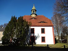
- Chapel of St. Margarethen and Nicolaus, it was built 1818–1819 with the support of the Glauch manor on the site of the old chapel, which was demolished in 1805. The wooden predecessor building, probably built in the 15th century as a path or pilgrimage chapel with a cemetery for foreign travelers, was repaired for the last time in 1624 at the instigation of the Alexey manor.
- Bollbuckmühle, it is in a dilapidated condition today
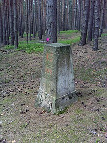
- Saxon-Prussian boundary stones No. 141–144
- Memorial stone for the fallen of the First World War
Individual evidence
- ↑ Cosel - HOV. Retrieved April 24, 2018 .
- ↑ As of December 15, 2012; Information from the residents' registration office in Königsbrück
- ↑ Hermann Knothe : History of the Upper Lusatian Nobility and its Goods: vom XIII. until the end of the XVI. Century. Volume 2. Leipzig 1879, p. 562
- ↑ Hermann Knothe : History of the Upper Lusatian Nobility and its Goods: vom XIII. until the end of the XVI. Century. Volume 1. Leipzig 1879, pp. 311-312
- ↑ Saxon State archive, 50155 Standesherrschaft Koenigsbrueck (D), no. 68 U
- ↑ Saxon State archive, 50155 Standesherrschaft Koenigsbrueck (D), no. 70 U
- ↑ Saxon State archive, 50155 Standesherrschaft Koenigsbrueck (D), no. 71 U
- ↑ Saxon State archive, 50155 Standesherrschaft Koenigsbrueck (D), no. 73 U
- ↑ The natural area of the Königsbrück military training area. Retrieved April 24, 2018 .
- ↑ Visitor concept for the Königsbrücker Heide
- ↑ FFH area "Teichgruppe Cosel - Zeisholz"
- ^ Cosel in the Digital Historical Directory of Saxony
- ↑ 2011 census
Web links
- Historical OT Cosel - Schwepnitz community. Retrieved April 24, 2018 .


