Salzbodenkopf
| Salzbodenkopf | ||
|---|---|---|
|
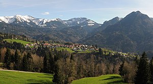
Panorama Dornbirner First to Hoher Staufen , in the center of the Salzbödenkopf |
||
| height | 1765 m above sea level A. | |
| location | Vorarlberg , Austria | |
| Mountains | Dornbirner First , Bregenz Forest Mountains | |
| Dominance | 1.36 km → Alpkopf | |
| Notch height | 160 m ↓ Fluhlöchle | |
| Coordinates | 47 ° 19 '49 " N , 9 ° 47' 37" E | |
|
|
||
| Normal way | from Ebnit , Ebnitertal and the Mellental ( Mellau ) on hiking trails | |
The Salzbodenkopf is a 1765 meter high mountain in the Bregenz Forest Mountains , which is located in the municipality of Dornbirn in Austria . The summit of the mountain is easily accessible on foot and belongs to the Dornbirner First , a mountain range that can still be easily recognized from Friedrichshafen on a clear day .
location
The Salzbodenkopf is about 2150 m as the crow flies northeast of the Mörzelspitze ( 1830 m above sea level ) and about 1430 m west of the Alpkopf ( 1788 m above sea level ).
On the flatter east side of the Salzbodenkopf (to Mellau), 850 m as the crow flies, the Oberbruderthanalpe (about 1490 m above sea level ) and about 1100 m as the crow flies is the Unterbruderthanalpe (about 1300 m above sea level ), to the southwest the Altenhofalpe (about 600 m as the crow flies to about 1600 m above sea level ). On the north-western side (Dornbirn) of the Salzbodenkopf, about 1150 m as the crow flies, the Unterfluhalpe is about 1186 m above sea level. A. situated.
All the Alps are easily accessible from the Ebnitertal, the mountain village Ebnit and the Mellental, which belongs to Mellau and is under nature protection. A little further to the south-east is the highest mountain in Dornbirn's municipality, the Sünser Spitze , and the striking Hohe Freschen .
summit
The Salzbodenkopf is largely covered with mountain pines . There is no summit cross on it.
Below the summit of saline soils head (Dornbirner side) to flow three streams together (eg Hornle trench.) And form with water kilometers 8.70 in plot "Loumwoad" ( clay - pasture ) the Gunzenach / Kobe Lach , which in turn in Gütle in the Dornbirner Oh ends up.
hike
The Dornbirner First and each of its peaks require surefootedness, sometimes a head for heights and alpine equipment with good mountain boots. The closest hiking base is the Freschenhaus ( 1846 m above sea level ). The surrounding Alps are partly cultivated in summer.
literature
- Dieter Seibert : Bregenzerwald and Lechquellen Mountains. Alpine Club Guide alpine. 1st edition. Bergverlag Rother, Munich 2008, ISBN 978-3-7633-1095-1 , p. 82 ff .

