San Antonio (Padcaya)
| San Antonio | ||
|---|---|---|
| Basic data | ||
| Residents (state) | 92 pop. (2012 census) | |
| height | 483 m | |
| Post Code | 06-0201-1202-1001 | |
| Telephone code | (+591) | |
| Coordinates | 22 ° 20 ′ S , 64 ° 7 ′ W | |
|
|
||
| politics | ||
| Department | Tarija | |
| province | Province of Aniceto Arce | |
| climate | ||
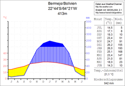
 Climate diagram Bermejo |
||
San Antonio is a town in the Tarija Department in the South American Andean state of Bolivia .
Location in the vicinity
San Antonio is a village in the canton of Tariquia in the district ( Bolivian : Municipio ) Padcaya in the eastern part of the province of Aniceto Arce . The village lies at an altitude of 483 m at the mouth of the Río Itaú in the Río Tarija , which from here forms the border with Argentina downstream .
geography
San Antonio is located on the southeastern edge of the Bolivian Andes chain in the transition to the Gran Chaco , which stretches across northwest Paraguay , northeast Argentina and southeast Bolivia. The climate is subtropical with hot humid summers and moderately warm and dry winters.
The annual average temperature is 21 ° C, the average monthly values fluctuate between 14 ° C in June and July and 26 ° C in December and January (see Bermejo climate diagram). The annual precipitation is about 950 mm, with a six-month dry season from May to October and a wet season from December to March with more than 150 mm monthly precipitation.
population
The population of the village has decreased by about a third over the past decade:
| year | Residents | source |
|---|---|---|
| 1992 | no data | census |
| 2001 | 135 | census |
| 2012 | 92 | census |
Transport network
San Antonio is located at a distance of 351 kilometers by road southeast of Tarija , the capital of the department.
The Ruta 1 trunk road runs through Tarija and, coming from Desaguadero on the Peruvian border, crosses the entire Altiplano and leads via the large cities of El Alto , Oruro , Potosí and Tarija to Bermejo on the Argentine border. Eight kilometers south of Tarija, Ruta 11 branches off from Ruta 1 in an easterly direction to Palos Blancos . From there the Ruta 29 leads south via Caraparí to Campo Pajoso .
Three kilometers southeast of Caraparí, the 169 km long Ruta 33 branches off in a south-westerly direction from Ruta 29 , which leads via San Alberto , Gutiérrez and Campo Largo to San Antonio and on to Bermejo on the Argentine border and from there via Ruta Nacional 50 is connected to the northern Argentine cities of Aguas Blancas and Pichanal .
Individual evidence
- ^ Instituto Nacional de Estadística Bolivia (INE) 1992
- ^ INE - Instituto Nacional de Estadística Bolivia 2001
- ↑ INE - Instituto Nacional de Estadística Bolivia 2012 ( Memento of the original from July 22, 2011 in the Internet Archive ) Info: The archive link has been inserted automatically and has not yet been checked. Please check the original and archive link according to the instructions and then remove this notice.
Web links
- Relief map of the Bermejo region 1: 250,000 (PDF; 1.15 MB)
- Municipio Padcaya - detailed map and population data (PDF; 670 kB) ( Spanish )
- Municipio Padcaya - General Maps No. 60201 ( Spanish )
- Departamento Tarija - social data of the municipalities (PDF; 3.05 MB) ( Spanish )
