Santa Ana (Vallegrande)
| Santa Ana | ||
|---|---|---|
| Basic data | ||
| Residents (state) | 146 pop. (2012 census) | |
| height | 2356 m | |
| Post Code | 07-0801-0113-4001 | |
| Telephone code | (+591) | |
| Coordinates | 18 ° 36 ′ S , 64 ° 9 ′ W | |
|
|
||
| politics | ||
| Department | Santa Cruz | |
| province | Vallegrande Province | |
| climate | ||
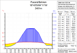
 Climate diagram Pucará |
||
Santa Ana is a town in the Santa Cruz Department in the South American Andean state of Bolivia .
Location in the vicinity
Santa Ana is a central place in the eponymous canton of Santa Ana in the district ( Bolivian : Municipio ) Vallegrande in the province of Vallegrande and is located at an altitude of 2356 m, twenty kilometers northeast of the confluence of the Río Mizque in the Bolivian Río Grande , 1,500 m above the river and separated from this by the ridge of the Serranía Río Grande .
geography
Santa Ana is located in the southwestern foothills of the Bolivian Cordillera Oriental . The climate is warm and temperate and a typical time of day climate in which the mean daily fluctuations in temperature are greater than the seasonal fluctuations.
The average annual temperature of the region is 14 ° C, the monthly averages fluctuate only slightly between 11 ° C in July and 16 ° C from November to January (see climate diagram Pucará). The annual precipitation is 650 mm, with a dry season with monthly values of less than 20 mm from May to September, the maximum precipitation values are between 100 and 125 mm in the summer months from December to February.
Transport network
Santa Ana is 252 kilometers by road from Santa Cruz , the capital of the department.
From Santa Cruz the highway Ruta 9 leads a few kilometers to El Carmen , and from there the Ruta 7 via La Angostura and Samaipata to Mataral . There the route 22 branches off in a southerly direction, which leads via Trigal and Vallegrande to Guadalupe . In Guadalupe , the Ruta 38 (the so-called " Ruta del Che ") branches off in a south-westerly direction, reaches Santa Ana after fifteen kilometers and continues via Pucará into the valley of the Río Grande . It crosses the river on a bridge and temporarily ends as Ruta 38 at the small town of Santa Rosa .
The Ruta del Che leads a few kilometers further south via Pucara to the village of La Higuera , where the Argentinian - Cuban revolutionary and guerrilla fighter Ernesto "Che" Guevara was shot by members of the Bolivian army on October 9, 1967 .
population
The population of the village has decreased by a third in the past two decades:
| year | Residents | source |
|---|---|---|
| 1992 | 232 | census |
| 2001 | 186 | census |
| 2012 | 146 | census |
Due to the population distribution that has evolved over time, the region has no significant concentration of indigenous populations. The only notable indigenous group in the village is the Quechua population, in the municipality of Vallegrande 2.4 percent of the population speak the Quechua language.
Individual evidence
- ^ INE - Instituto Nacional de Estadística Bolivia 1992
- ^ INE - Instituto Nacional de Estadística Bolivia 2001
- ↑ INE - Instituto Nacional de Estadística Bolivia 2012 ( Memento of the original from July 22, 2011 in the Internet Archive ) Info: The archive link has been inserted automatically and has not yet been checked. Please check the original and archive link according to the instructions and then remove this notice.
- ↑ INE social data (PDF; 5.2 MB)
Web links
- Municipio Vallegrande - General Maps No. 70801
- Municipio Vallegrande - detailed map and population data (PDF 1.51 MB) (Spanish)
- Santa Cruz Department - Social data of the municipalities (PDF 4.99 MB) ( Spanish )
