Gamsstein
| Gamsstein | ||
|---|---|---|
|
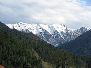
Gamsstein from the north ( Hollenstein ) with Gamssteineck ( 1766 m , right at the edge of the picture) and Hochkogel ( 1774 m , left of it) |
||
| height | 1774 m above sea level A. | |
| location | Lower Austria and Styria , Austria | |
| Mountains | Ybbstal Alps | |
| Dominance | 9.4 km → Hochkar | |
| Notch height | 1094 m ↓ Mendling Pass | |
| Coordinates | 47 ° 43 '46 " N , 14 ° 46' 39" E | |
|
|
||
| rock | Wetterstein lime | |
| Age of the rock | Anisium - Carnium | |
The Gamsstein is an isolated mountain range in the Ybbstal Alps on the Styrian - Lower Austrian border. Its highest peak is the Hochkogel with a height of 1774 m above sea level. A.
Location and structure
The Gamsstein rises in the area of the Styrian communities Landl and Altenmarkt near Sankt Gallen and the two Lower Austrian communities Göstling an der Ybbs and Hollenstein an der Ybbs . The state border mostly runs along the watershed between Enns and Ybbs . The mountain range is mainly made up of Wetterstein limestone. The Hasel Mountains , the Reifling Formation and the Lunz Formation also emerge at the southern foot of the mountain , while the main dolomite can be found in lower areas on the north side of the mountain .
The Gamsstein has an approximately three-kilometer-long summit ridge that extends from southwest to northeast. It first reaches the 1766 m high Gamssteinck and further northeast the Hochkogel 1774 m, separated by a cut . To the east, the Gamssteinkamm widens to a small trough-like plateau with the former Moarhochalm , before it descends further to the alpine pasture area of the Niederscheibenberg (around 1200 m ).
Towards the north, the mountain falls into steep crags interspersed with mountain grass and rock faces towards the Seebach valley . To the south, the Gamsstein has steep meadows in the uppermost area that drop into smaller cirques . To the east of the Gamsstein is a high plateau with the Scheibenberg, which reaches 1400 m at its southeastern end in Zinken . To the north forms Gscheidsattel ( 1026 m ) to connect to the almost equally high Voralpe ( butt wall , 1,770 m ).
history
The earliest written evidence is from 1139 and is "Kamezenstein". The name goes back to Slavic Kamenica (quarry, stony place) and Old High German stone .
Tourist development
Tour options for the Gamsstein were first published in 1871 in the yearbook of the Austrian Alpine Association by Wilhelm Schleicher . In 1959 , a large summit cross was erected on a pre-summit ( 1770 m ) of the Hochkogel, around 250 meters northeast of the main summit . As a hut Base can be found on the south side of the Gamssteins to 1020 m , the mountain farmers Lackner hut of Friends of Nature , which is farmed in the summer season on weekends.
The Hochkogel and its more popular pre-summit with the summit cross can be reached from the south ( Palfau ) as well as from the north (Sandgraben or Promau ) via marked paths, which only require some surefootedness in the final sections . On the south side, the Gamsstein can be reached directly via the Bergbauern-Lackneralmhütte and the Hühnerriegel , whereby the path joins the ridge at the summit cross of the pre-summit. From the east, the ascent takes place via the Niederscheibenalm, the Moarhochalm and then always in the immediate vicinity of the ridge. In winter, the Gamsstein is a regular destination for ski tours, mostly from Palfau, with the ascent and descent almost exactly in the fall line of the summit cross over the Hühnerriegel.
Gamsstein lifts
In the 1970s there were plans to build a large ski area on the gentler east side of the Gamsstein. In 1979 a double chair lift to the Niederscheibenberg from Sandgraben and a double drag lift to the Kleinpromaualm were opened. Further expansion plans for the Moarhochalm were not implemented. After financial difficulties, the lifts were dismantled after a few years.
swell
- ↑ Eberhard Jurgalski : Complete table of summits in the Alps separated by 590 meters of re-ascent , December 12, 2008.
- ^ Federal Office for Metrology and Surveying Austria: Austrian Map online (Austrian map 1: 50,000) .
- ^ Geological map of the Republic of Austria 1: 50,000, published by the Federal Geological Institute , Vienna 2001, sheet 100 Hieflau
- ↑ Fritz Frhr. Lochner von Hüttenbach: On the name property of the early Middle Ages in Styria (= magazine of the Historical Association for Styria . Volume 99 ). Böhlau Verlag, Vienna 2008, p. 57 ( historerverein-stmk.at [PDF; 16.9 MB ]).
- ^ Wilhelm Schleicher: From the Lower Austrian Alps in the yearbook of the Austrian Alpine Association , Vienna 1871.
- ↑ www.palfau.at
- ↑ Friends of nature, mountain farmers - Lacknerhalmhütte , (as of November 9, 2012)
- ↑ Helmut Prevedel: Schitourenführer Steiermark - Over 500 tours , 2nd edition, Verlag Styria, Graz 1995, ISBN 3-222-12352-7 , p. 44.
- ^ Werner Tippelt, Bernhard Baumgartner: Skiing in Lower Austria . Niederösterreichisches Pressehaus Druck- und Verlagsgesellschaft mbH, St. Pölten, 1979. ISBN 3-85326-484-0 .

