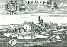
Hirschhorn Castle

The abandoned Hirschhorn Castle (originally called Hirzar ) is located in the district of the same name in the Lower Bavarian community of Wurmannsquick in the Rottal-Inn district (Hirschhorn, house no. 17 1/2).
history
Hirschhorn (or Hirzar) is probably first mentioned in a document in the Notitia Arnonis from 790 (there are two churches in the lower part of the city , one of which could be Hirschhorn). At that time the area belonged to the bishopric of Salzburg . In the 12th century, the Ortenburg ministerial family von Hirschhorn lived here. 1165 Walchounus de Hirzar is named with his miles as the Ministeriale of Count Rapoto I. von Ortenburg . Further representatives of this sex were Hartwicus , Hermann , Friedrich and Erhart . A Wernhart was married to a woman Lita . Konrad von Hirschhorn sold his fiefdom in 1333 to Heinrich Altenburger . On June 26, 1339 an Erhart Hirsoraer is documented. However, by January 25, 1339 at the latest, Heinrich Altenburger was in the possession of Hirschhorn.
Through the marriage of Dorothea , daughter of Mattheus Altenburger , with Jörg Closen , Hirschhorn came to this family ( investiture 1434). In the 15th century, Hirschhorn appears as a fiefdom of the Regensburg bishopric . After Dorothea's death († 1474), violent inheritance disputes occurred between the Zengers , the Preysingers and the Closen over Hirschhorn. The feudal court decided that Hirschhorn should come to the Zengers, who were related to said Dorothea. Representatives of the Zengers, who named themselves after Hirschhorn, were Hans Zenger and his sons Friedrich , Tristram and Siegmund . After the death of Tristram, who had left no male heirs, the husbands of the female Zenger's heirs raised a claim to Hirschhorn in 1535. These were David von Trautmannsdorf , Ulrich von Lapitz , David von Puchberg and Jorg Perger zu Wegleiten . The Regensburg Monastery and Hans Closen zu Gern also seem to have interfered in the inheritance dispute.
In 1550 and 1737 Hirschhorn appears as a closed Hofmarch .
Through contracts with the Hochstift Regensburg in 1535 and financial compensation to the Zenger's heirs in 1542/43, Hanns Christoph Closen finally received Hirschhorn. On June 12th 1642 Hirschhorn passed from Hanns Jacob Freiherr von Closen zu Hellsberg to his widow Elisabeth Barbara , née Lösch. From this, Hirschhorn reached Hanns Georg Freiherr von Closen zu Gern on the Kaufweg on May 18, 1655 . After the death of Georg Cajetan Count von Closen zu Gern and Oberarnstorf († 1780) Hirschberg comes to his daughter Maria Anna , married Freiin von Ingenheim , who has to compare it with her sister Maria Theresia, married Countess von Dachsberg.
The Hirschhorn community was established in 1818. On March 31, 1821, Baroness von Ow , née Baroness von Wening-Ingenheim, is listed on Hirschhorn as the judge of the Patrimonial Court II . On the way of exchange, Baroness von Ow received the allodification document and in return renounced the patrimonial jurisdiction in favor of the state. On January 1, 1972, the dissolved community of Hirschhorn came to Wurmannsquick.
building
On the engraving by Michael Wening from 1721, the castle is a typical low castle . The simple three-storey building stands on a small hill surrounded by water. Two farm buildings can also be seen on this. A simple wooden bridge leads to the property. A Sedelhof can be seen outside the moat . The parish church of St. Rupertus von Hirschhorn can be seen behind it. This exposed brick building is a late Gothic complex from the 15th century. The medieval or early modern moated castle stable is a listed building .
literature
- Rita Lubos: The Eggenfelden district court . (= Historical Atlas of Bavaria, part of Old Bavaria. Issue 28). Commission for Bavarian History, Michael Lassleben Verlag, Munich 1971, ISBN 3-7696-9874-6 , pp. 135-139.
Web links
- Entry on Hirschhorn Castle in the private database "Alle Burgen".
- Hirschhorn on regiowiki
Individual evidence
- ↑ List of monuments for Wurmannsquick (PDF) at the Bavarian State Office for Monument Preservation
Coordinates: 48 ° 21 ′ 55.7 " N , 12 ° 45 ′ 31.2" E

