
Theisenort Castle

The Castle Theisenort is located in the settlement Theisenort, a district of the municipality of Küps in Upper Franconian district of Kronach in Bavaria .
Geographical location
Theisenort lies in the middle of the extensive valley landscape of the central Rodach . The favorable location of the place on this river, which served as a transport route in the Middle Ages , established the establishment of a total of ten aristocratic residences in the area of the Küps market, to which Theisenort belongs. Nine of the ten properties still exist, some of which have been heavily modified or as ruins or ground memorials .
Theisenort Castle is located on the northeastern edge of the municipality in the street Am Schlossberg.
history
In a purchase contract from the year 1335, a noble residence on the mountain cone above the village is mentioned for the first time in Theisenort. The knights Eberhard and Konrad von Kotzau sold their property to the Bamberg bishopric , which passed it on to Iring von Redwitz only a few years later . In 1390 it was again transferred to the bishopric as a fief .
In the Peasants' War of 1525 , the rebels looted and pillaged the Theisenort fortress. It was rebuilt by 1528. In the Thirty Years' War Veit von Redwitz supported the Swedish troops in contrast to the imperial city of Kronach . After the suppression of the Swedes, Veit's entire property should fall to Kronach, but this was prevented by the influence of Protestant princes. The Theisenort property remained in the possession of the Barons von Redwitz for more than 500 years. Only Oskar von Redwitz sold the castle, which had meanwhile been converted into a castle, to the Counts of Egloffstein in 1862 , but they sold it to Julius Eckart in 1909, whose descendants still hold the property.
In 1947 the castle was struck by lightning and burned down completely. The castle character was lost through the reconstruction as a residential building.

"Old Guard"
"Alte Wache" and former brewery

Former castle brewery

Theisenort Castle - new part


buildings
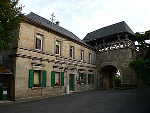
Old guard
At the end of the steep driveway to the Schlossberg you first come to the so-called Alte Wache. It belongs to the bailey in front of the castle from the 14th century and represents the oldest part of the preserved complex. Above the gate passage, which is pointed on the outside and round on the inside, runs an open battlement with a sandstone parapet structured by tracery . The coat of arms of Wilhelm von Redwitz from 1675 is on one of the posts supporting the roof made of beams. A round corner tower with horizontal loopholes is attached to the three-storey gate . In the 15th century, the gate wing was extended to the west, the current shape of which dates from 1586.
Outer bailey

To the right of the gate building, to the east, there was initially only a circular wall, which became the outer wall of the castle inn in 1860 when the new castle inn was built. Immediately behind it is a barn with a gable roof , which was built from half-timbered timber on the northern outer wall of the outer bailey in the 17th century. It served as a tithe barn to store taxes in kind from the farmers. A double coat of arms from 1568 with the initials "WVR KVRGK" (Wilhelm von Redwitz and Katharina von Redwitz née Koller) is attached to another sandstone wall of the outer bailey.
lock
The actual castle above the outer bailey has been a simple, rectangular, plastered building with three floors and a hipped roof since its reconstruction in 1950 . The only decoration is a colored glazed Redwitz coat of arms from the 16th century above the portal on the south front, which can be reached via a five-step flight of steps. The oldest parts in the east side of the building are preserved in the form of rubble stones and toothed corner cuboids . On this side there is a small two-storey extension with a diagonally placed rectangular tower attached to the northeast corner. Below the castle building, cellars and underground passages have been cut into the rocks of the northeast slope, which were originally accessible from the castle and have been partially preserved.
church

The simple, rectangular Simultaneous Church of the Holy Trinity stands below the castle on a terrace on the southern slope of the Schlossberg . It was consecrated as a Protestant church in 1699. Catholic worship has also been celebrated there since 1830. The previous buildings of the castle church were two chapels from the years 1357 and 1497/98. In today's church there is a baptismal font from the 16th century and a five-part sculptural group of the Coronation of Mary . Above the arched west portal is an alliance coat of arms of Georg Christoph von Redwitz and Ursula Margaretha Regina von Boyneburg with the year 1698.
literature
- Tilmann Breuer: Bavarian art monuments, district of Kronach . Volume XIX, Deutscher Kunstverlag, Munich 1964.
- Albert Elstner: The von Künsberg: the story of a Franconian. Noble family . Heim Verlag, Darmstadt 1972.
- Fritz Mahnke: Palaces and castles in the vicinity of the Franconian Crown, 2nd volume . Druck- und Verlagsanstalt Neue Presse GmbH, Coburg 1978, pp. 135-137.
- Heinrich Pöhlmann: History of the market town Küps . Schulze Verlag, Lichtenfels 1908.
- Hans Schleicher: The history of the market Küps . Frank de la Porte publishing house, Küps 1996, ISBN 3-932416-00-7 .
Web links
Individual evidence
- ^ Fritz Mahnke: Palaces and castles around the Franconian Crown ; Volume 2; Neue PRESSE printing and publishing company; Coburg; 1978; Pp. 141-145
- ↑ Bavarian Office for the Preservation of Monuments: Architectural and ground monuments in Küps (PDF; 145 kB)
- ^ Fritz Mahnke: Palaces and castles around the Franconian Crown ; Volume 2; Neue PRESSE printing and publishing company; Coburg; 1978; Page 135
- ↑ a b c Fritz Mahnke: Palaces and castles in the vicinity of the Franconian Crown ; Volume 2; Neue PRESSE printing and publishing company; Coburg; 1978; Page 136
- ^ A b Fritz Mahnke: Palaces and castles in the vicinity of the Franconian Crown ; Volume 2; Neue PRESSE printing and publishing company; Coburg; 1978; Page 137


Castles: Alte Kemenate Castle (Nagel) | Upper Fischbach Castle | Lower Fischbach Castle | Middle Fischbach Castle | Upper Friesen Castle | Lower Castle Friesen | Middle Castle Friesen (exited) | Haig Castle | Castle Hain | Hesselbach Castle (exited) | Hohenrot Castle (exited) | Rear (new) Küps Castle | Middle (old) Küps Castle | Upper Küps Castle (Schemenau) | Ludwigsstadt Palace | Upper Castle (Mitwitz) | Mitwitz moated castle | Oberlangenstadt Castle | Schmölz Castle | Seibelsdorf Castle | Stockheim Castle | Theisenort Castle | Moated Castle Tüschnitz (removed)
Castles and ruins: Burggut Birkach | Heunischenburg | Lauenstein Castle | Rothenkirchen Castle | Waldenfels Castle (exited) | Wildenberg Castle (removed)
Fortifications: Rosenberg Fortress
Tower hill castles (all gone): Tower hill Altes Schloss (Haßlach) | Tower Hill Alter Schlossberg (Kathragrub) | Buchbach Tower Hill | Tower Hill The Bastion | Entmannsdorf Tower Hill | Tower Hill Haßlach | Hirschfeld Tower Hill | Tower Hill Ludwigsstadt | Tower Hill Obere Bürg | Seibelsdorf tower hill | Welitsch tower hill
Manor houses: Hofgut Melanger
Castle stables (lost, unknown castles): Burgstall Am Schlossberg | Burgstall The Castle | Burgstall Ludwigsstadt | Burgstall Rothenkirchen | Burgstall Schlossberg (North Halben) | Burgstall Schlossberg (Seibelsdorf) | Burgstall Schlossberg (Steinwiesen) | Black Geis Castle Stables (Steinberg Castle) | Burgstall Steinberg | Section fortification Sternberg | Tschirn Castle Stables
Coordinates: 50 ° 12 ′ 56.2 ″ N , 11 ° 16 ′ 48.4 ″ E