Schwarzeck (Bavarian Forest)
| Schwarzeck | ||
|---|---|---|
|
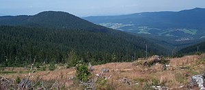
View from Heugstatt to Schwarzeck (left), Lamer Winkel and Ossergipfel (top right) |
||
| height | 1235.8 m above sea level NHN | |
| location | Border district Cham and district Regen , Bavaria ( Germany ) | |
| Mountains | Bavarian forest | |
| Dominance | 3.9 km → Kleiner Arber | |
| Notch height | 103 m ↓ Reischflecksattel | |
| Coordinates | 49 ° 8 '48 " N , 13 ° 3' 52" E | |
|
|
||
| rock | Gneiss | |
The Schwarzeck is a 1235.8 m above sea level. NHN high mountain in the Bavarian Forest , which rises in the Arberkamm between the Heugstatt ( 1262 m ) in the south and the Ödriegel ( 1156 m ) in the west-northwest.
description
The summit of the Schwarzeck lies on the municipal border between Lohberg and Arnbruck , i.e. also on the border between the districts of Cham in the Upper Palatinate and Regen in Lower Bavaria .
The Schwarzeck is one of the lesser-known Bavarian Forest Mountains, but it is accessible via a number of hiking trails. A possible variant of the ascent is the ascent via the Hüttensteig and then along the south ridge (pathless and only with sturdy shoes, sometimes easy climbing). Most hikers pass the Schwarzeck along the E6 long-distance hiking trail from the Arber to the Kaitersberg . Further climbs lead from Arnbruck , Schareben or Lohberg to the summit.
In 1970 a summit cross was erected at the main summit, which was renewed in 2006.
The view of the Lamer Winkel , the Osser , the Zellertal and the Kaitersberg opens up from the two summit rocks . Since hurricane Kyrill knocked down countless trees on the mountain in 2007, one can see the entire Lamer Winkel from the rocky summit ridge.


