
Selez (Drohobych)
| Selez | |||
| Селець | |||

|
|
||
| Basic data | |||
|---|---|---|---|
| Oblast : | Lviv Oblast | ||
| Rajon : | Drohobych district | ||
| Height : | 342 m | ||
| Area : | 2.1 km² | ||
| Residents : | 164 (2001) | ||
| Population density : | 78 inhabitants per km² | ||
| Postcodes : | 82123 | ||
| Area code : | +380 3244 | ||
| Geographic location : | 49 ° 27 ' N , 23 ° 18' E | ||
| KOATUU : | 4621287803 | ||
| Administrative structure : | 3 villages | ||
| Address: | вул. Перемоги 1 82123 с. Ступниця |
||
| Statistical information | |||
|
|||


Selez ( Ukrainian Селець ; Russian Селець , Polish Sielec ) is a village in Drohobych Rajon in Lviv Oblast in western Ukraine , around 13.5 km southeast of Sambir . The history of the village, which today has around 160 inhabitants, goes back at least to the beginning of the 16th century.


Selez together with the villages Kotowane ( Котоване ) and Stupnyzja ( Ступниця ) the District Municipality Stupnyzja, north of the village is the village and the forest of Side ( Сіде ), to the east Horodyshche ( Городище ), in the south Mokrjany ( Мокряни ) and to the west Wilschanyk . Geographically, the area is located in Dniesterbecken , between the tributaries Bystrytsia River and Czerchawa.
history
The village was first mentioned in a document from 1559 in 1538. King Michael I Korybut Wiśniowiecki established the parish between 1669 and 1673, at which time a royal church was built. Another church with its own parish for the local Polish nobility ( szlachta ) was built later, both parishes coexisted before they were later merged.
While the area was property of the Crown, the Dżurdż family was at an unknown time half of it as a fief given. Around 1650, King John II Casimir granted the Cossack - Ataman Skrebeciowicz the other half of the Selez property, as well as the right to wear the Sas coat of arms for his loyal service to the crown during the Khmelnitsky Uprising . After the partition of Poland in 1772, the southern part of Poland fell to Austria . The privileges of the noble Skrebeciowicz de Sielecki family were confirmed by the new sovereigns in Vienna and the hereditary title of knight was conferred.
According to historical documents, Selez had a total population of 781 in 1880. Broken down by denomination , 657 were Greek Catholics , 32 were Roman Catholics , 58 were Jewish and seven were other faiths. According to the 1889 census, 728 spoke Ukrainian as their first language, 50 Polish and three German . At the time there were 172 houses, the manor and the estates employed around 47 people.
The area changed hands several times. After the collapse of the Austro-Hungarian dual monarchy in 1918, Selez returned to the newly independent Poland and administratively became part of the Lviv Voivodeship . After the German-Soviet invasion of Poland at the end of September 1939 and in accordance with the German-Soviet non-aggression pact , the Lviv Voivodeship was divided by both sides. Selez was occupied by the Soviets and became part of the Ukrainian Soviet Socialist Republic , only to be overrun by the German Wehrmacht again in the summer of 1941 . After the war it finally came to Ukraine. Due to the war and the Stalinist persecution, the population fell sharply. The local Jewish population was expelled or murdered during the Holocaust , members of the local nobility, wealthy peasants and non-Ukrainians were either executed by the Soviets or deported to the Gulags in Siberia . The remaining farmers and the population were forced to collectivize their property . After the fall of the Iron Curtain in 1989, the local collective farm , the largest economic employer, collapsed. The high unemployment led to rural exodus to the cities, especially among young people. The 2001 census counted 164 inhabitants, in 2009 the village consisted of about 40 houses.
Attractions
The area is characterized by rolling hills and agricultural areas rich in black earth. The economy consists mainly of agriculture, with livestock raising cattle and horses. The old mansion has been lost over time, as has the royal church mentioned in the historical annals. The church for the nobility still exists.
The Greek Catholic Church of Our Lady (Ukrainian: Богородицка Церква ) is located on a hill. Together with the bell tower , it is a typical example of rural Ukrainian wooden churches. Built in the 17th century , it is surrounded by a historic cemetery. The church was donated by the local nobility, members were buried in the cemetery. During communist rule, the church was closed and deteriorated. Only after the end of the communist regime was the church restored with donations. Today it is a listed building.
The floor plan is cruciform and consists of three parts: the narthex on the front, the nave in the middle and the apse on the back, which is shielded by an iconostasis . The church is about eighteen meters long and eight meters wide, the nave is less than six meters away. The center of the nave is covered by a small octagonal dome with ornate religious images in white and light blue. The floor is covered with carpets. The iconostasis probably dates back to the 19th century. The benches on the left side of the church were reserved for the nobility, while the Ruthenian peasants either stood or sat on the right side. The church originally had a higher main dome, but it had to be demolished due to disrepair around or after the 1970s.
A little away from the foot of the hill is the smaller chapel of the Holy Apostles Peter and Paul . Built of cement, it was inaugurated on July 12, 2000 to celebrate the turn of the millennium . It replaced an earlier wooden chapel that was dilapidated, originally only used by the farmers.
The new cemetery is along the road to the village. From Selez on the way to Drohobych there is a memorial in the forest for the Jews of the area who perished in the Shoah.
Picture gallery
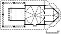
Floor plan of the Church of Our Lady

One of the oldest gravestones of those von Sielecki in the old cemetery
Grave of Olga Sielecka (1908–1931) in the old cemetery

Chapel of the Holy Apostles Peter and Paul
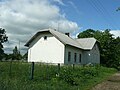
School and meeting house

Village shop ПРОДУКТИ ("PRODUKTY")

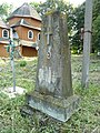
Cross that was erected in 2002 opposite the new cemetery
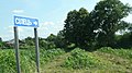
Place name sign for Selez on the road between Sambir and Drohobytsch


literature
- Olena Krushynska: 44 wooden churches in the Lviv region . Grani-T, Kiev 2007, ISBN 978-966-465-076-9 , pp. 62–64 (Ukrainian, derev.org.ua [accessed December 30, 2009] Original title: Сорок чотири дерев'яні храми Львівщини .).
- V. Slobodyan: Церкви України. Перемиська єпархія . Lemberg 1998, p. 863 (Ukrainian).
- Sielec . In: Filip Sulimierski, Bronisław Chlebowski, Władysław Walewski (eds.): Słownik geograficzny Królestwa Polskiego i innych krajów słowiańskich . tape X . Warsaw 1889, p. 530-531 (Polish, online [accessed December 30, 2009]).
Web links
- Sielec . In: Filip Sulimierski, Władysław Walewski (eds.): Słownik geograficzny Królestwa Polskiego i innych krajów słowiańskich . tape 10 : Rukszenice – Sochaczew . Walewskiego, Warsaw 1889, p. 530 (Polish, edu.pl ).
Individual evidence
- ↑ "AD 1538 donat Magnificus Petrus Odrowaz Weryzy et illius successoribus, curiam alias dworyszcze 'Waczewo' in villa Sielcze, cum pratis, agris, silvis, mericis, robetis, mellificiis, earumque decursibus, ad dictam aream Waczewo spectantibus, et dictam aream Waczewo spectantibus, et dictam aream Waczewo spectantibus Potok Uruszny nuncupatam, inter prata ejusdem areae decurrens cum ambabus ryppis. Quam donationem Sigismundus Augustus rex approbat AD 1559. “Rkp. Ossolineum , No. 2837, str. 81.
- ^ War Archives of the Austrian State Archives .
- ↑ a b c Sielec . In: Filip Sulimierski, Bronisław Chlebowski, Władysław Walewski (eds.): Słownik geograficzny Królestwa Polskiego i innych krajów słowiańskich . tape X . Warsaw 1889, p. 530-531 (Polish, online [accessed December 30, 2009] Lexicon).
- ↑ Photo of the information board attached to the chapel by the Ukrainian Monument Protection Agency (Ukrainian, May 30, 2009)
- ↑ a b Viktor Gromyko: СОБОРУ ПР. БОГОРОДИЦІ 1700., с.Селець, Дрогобицький р-н. In: ДЕРЕВ'ЯНІ ЦЕРКВИ ЛЬВІВЩИНИ. Archived from the original on April 5, 2008 ; Retrieved December 30, 2009 (Ukrainian, 2007–2008).
- ↑ Photo of the information board attached to the chapel by the Ukrainian Monument Protection Agency (Ukrainian, May 30, 2009)