Selle (Somme)
| Selle | ||
|
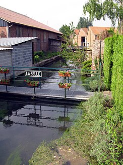
The Selle in Lœuilly |
||
| Data | ||
| Water code | FR : E6420600 | |
| location | France , Hauts-de-France region | |
| River system | Somme | |
| Drain over | Somme → English Channel | |
| source | in the municipality of Catheux 49 ° 39 ′ 12 ″ N , 2 ° 7 ′ 7 ″ E |
|
| Source height | approx. 110 m | |
| muzzle | in the urban area of Amiens in the Somme coordinates: 49 ° 54 ′ 28 " N , 2 ° 16 ′ 49" E 49 ° 54 ′ 28 " N , 2 ° 16 ′ 49" E |
|
| Mouth height | approx. 20 m | |
| Height difference | approx. 90 m | |
| Bottom slope | approx. 2.3 ‰ | |
| length | 39 km | |
| Right tributaries | Évoissons | |
| Big cities | Amiens | |
The Selle (in the upper reaches also: Celle ) is a river in France that runs in the Hauts-de-France region . It rises in the municipality of Catheux , generally drains in a north-easterly direction and flows into the Somme as a left tributary after 39 kilometers in the urban area of Amiens . On her way she crosses the Oise and Somme departments .
Places on the river
- Catheux
- Fontaine-Bonneleau
- Croissy-sur-Celle
- Conty
- Lœuilly
- Plachy Buyon
- Vers-sur-Selles
- Saleux
- Salouël
- Amiens
Web links
Commons : Selle - collection of images, videos and audio files
