Fontaine-Bonneleau
| Fontaine-Bonneleau | ||
|---|---|---|
|
|
||
| region | Hauts-de-France | |
| Department | Oise | |
| Arrondissement | Beauvais | |
| Canton | Saint-Just-en-Chaussée | |
| Community association | Oise Picarde | |
| Coordinates | 49 ° 40 ′ N , 2 ° 9 ′ E | |
| height | 72-175 m | |
| surface | 16.37 km 2 | |
| Residents | 244 (January 1, 2017) | |
| Population density | 15 inhabitants / km 2 | |
| Post Code | 60360 | |
| INSEE code | 60240 | |
 Town hall and school building |
||
Fontaine-Bonneleau is a French municipality with 244 inhabitants (at January 1, 2017) in Oise in the region of Hauts-de-France . The municipality is located in the arrondissement of Beauvais and is part of the Communauté de communes de l'Oise Picarde and the canton of Saint-Just-en-Chaussée .
geography
The rural community is located on the upper reaches of the Selle (Celle), which flows into the Somme in the urban area of Amiens , around nine kilometers northeast of Crèvecœur-le-Grand . The abandoned railway line from Amiens to Beauvais , which was dismantled in this section, ran through them . Today's hamlet Bonneleau is about a kilometer north of Fontaine. The isolated farm Ferme du Bois de la Haie belongs to the municipality.
history
The use of the local mineral springs began in 1770. In the 19th century there were five mills on the Selle, next to them there was a lime kiln and a quarry.
Residents
| 1962 | 1968 | 1975 | 1982 | 1990 | 1999 | 2006 | 2011 |
|---|---|---|---|---|---|---|---|
| 329 | 318 | 292 | 279 | 252 | 287 | 288 | 264 |
administration
Mayor ( maire ) has been Didier Cornet since 2008.
Attractions
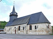
- Saint-Cyr and Sainte-Julitte Church
- Saint-Georges church in Bonneleau
- Castle between the two parts of the community
Individual evidence
- ↑ http://clochers.org/Fichiers_HTML/Accueil/Accueil_clochers/60/accueil_60240a.htm
- ↑ http://clochers.org/Fichiers_HTML/Accueil/Accueil_clochers/60/accueil_60240.htm

