Saint-Arnoult (Oise)
| Saint-Arnoult | ||
|---|---|---|
|
|
||
| region | Hauts-de-France | |
| Department | Oise | |
| Arrondissement | Beauvais | |
| Canton | Grandvilliers | |
| Community association | Picardy Verte | |
| Coordinates | 49 ° 38 ′ N , 1 ° 49 ′ E | |
| height | 164-212 m | |
| surface | 7.90 km 2 | |
| Residents | 217 (January 1, 2017) | |
| Population density | 27 inhabitants / km 2 | |
| Post Code | 60220 | |
| INSEE code | 60566 | |
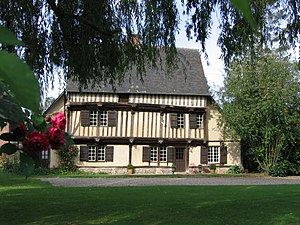
 Former priory |
||
Saint-Arnoult is a French municipality with 217 inhabitants (at January 1, 2017) in Oise in the region of Hauts-de-France . The municipality is located in the arrondissement of Beauvais and is part of the Communauté de communes de la Picardie Verte and the canton of Grandvilliers .
geography
The community is about eight kilometers east-southeast of Formerie . It includes the Colagnie-des-Fenêts farmsteads, the Colagnie-des-Bois castle and the hamlet of Marcoquet.
Residents
| 1962 | 1968 | 1975 | 1982 | 1990 | 1999 | 2006 | 2011 |
|---|---|---|---|---|---|---|---|
| 274 | 281 | 241 | 203 | 173 | 172 | 176 | 188 |
administration
Mayor ( maire ) has been Noël Bouton since 2001.
Attractions
- Building of the Saint-Arnoult Priory (15th century), originally from the Abbey of Saint-Germer-de-Fly , later dependent on the Abbey of Beaubec , a half-timbered construction, registered as a monument historique since 1988
- Garden of the priory
Individual evidence
- ^ Prieuré in the Base Mérimée of the French Ministry of Culture (French)
- ↑ http://www.jardinez.com/Parcs-et-jardins-Jardin-du-Prieure-de-Saint-Arnoult_Saint-Arnoult_Oise_Picardie-France_fr_14482.html
Web links
Commons : Saint-Arnoult - Collection of images, videos and audio files
