Wambez
| Wambez | ||
|---|---|---|
|
|
||
| region | Hauts-de-France | |
| Department | Oise | |
| Arrondissement | Beauvais | |
| Canton | Grandvilliers | |
| Community association | Picardy Verte | |
| Coordinates | 49 ° 32 ' N , 1 ° 51' E | |
| height | 119-208 m | |
| surface | 4.54 km 2 | |
| Residents | 164 (January 1, 2017) | |
| Population density | 36 inhabitants / km 2 | |
| Post Code | 60380 | |
| INSEE code | 60699 | |
 Mairie Wambez |
||
Wambez is a French municipality with 164 inhabitants (at January 1, 2017) in Oise in the region of Hauts-de-France . The municipality is located in the arrondissement of Beauvais and is part of the Communauté de communes de la Picardie Verte and the canton of Grandvilliers .
geography
The municipality in the Pays de Bray is about four kilometers south of Songeons on the Ruisseau de Wambez stream; it borders in the north against Buicourt and Gerberoy on the Ruisseau de Bellefontaine stream (both tributaries of the Thérain ). It includes the hamlet of Les Coutumes and the isolated farms of le Bosquet aux Loups, la Ferme Brûlée and la Havotière.
Toponymy
The municipality name is probably of Germanic origin (see Wambeek, municipality of Ternat , in Belgium, Wambaix in the north department ).
Residents
| 1962 | 1968 | 1975 | 1982 | 1990 | 1999 | 2006 | 2011 |
|---|---|---|---|---|---|---|---|
| 100 | 80 | 115 | 148 | 118 | 123 | 154 | 149 |
administration
Mayor ( maire ) has been Jacky Durand since 2008.
Attractions
- Saint-Martin Church (see also: List of Monuments historiques in Wambez )
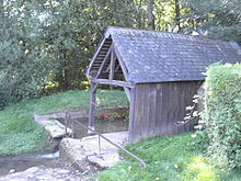
- Wash house


