Montagny-en-Vexin
| Montagny-en-Vexin | ||
|---|---|---|

|
|
|
| region | Hauts-de-France | |
| Department | Oise | |
| Arrondissement | Beauvais | |
| Canton | Chaumont-en-Vexin | |
| Community association | Vexin Thelle | |
| Coordinates | 49 ° 12 ′ N , 1 ° 48 ′ E | |
| height | 87-203 m | |
| surface | 4.18 km 2 | |
| Residents | 669 (January 1, 2017) | |
| Population density | 160 inhabitants / km 2 | |
| Post Code | 60240 | |
| INSEE code | 60412 | |
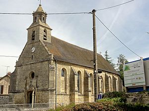
 Saint-Jacques-Saint-Christophe Church |
||
Montagny-en-Vexin is a French municipality with 669 inhabitants (at January 1, 2017) in Oise in the region of Hauts-de-France . The municipality is located in the arrondissement of Beauvais and is part of the Communauté de communes du Vexin Thelle and the canton of Chaumont-en-Vexin .
geography
The municipality is located around five and a half kilometers north of Magny-en-Vexin on the border with the Val-d'Oise department . The districts of La Maladrerie and Les Fermettes belong to Montagny. The stream Cudron rises on the border with the municipality of Montjavoult .
Toponymy and History
The community name is derived from the Latin Montaniacum. The castle was destroyed in the League Wars . In 1788 Montagny was separated from Montjavoult.
economy
Various companies have set up shop in the Zone Industrial de la Molière business park.
Residents
| 1962 | 1968 | 1975 | 1982 | 1990 | 1999 | 2006 | 2011 |
|---|---|---|---|---|---|---|---|
| 170 | 162 | 242 | 376 | 528 | 554 | 528 | 616 |
administration
Loïc Taillebrest has been mayor ( maire ) since 2014.
Attractions
- Saint-Jacques-Saint-Christophe Church. (see also: List of Monuments historiques in Montagny-en-Vexin )
- Calvaire in the square in front of the Mairie


