Fontenay-Torcy
| Fontenay-Torcy | ||
|---|---|---|
|
|
||
| region | Hauts-de-France | |
| Department | Oise | |
| Arrondissement | Beauvais | |
| Canton | Grandvilliers | |
| Community association | Picardy Verte | |
| Coordinates | 49 ° 34 ′ N , 1 ° 46 ′ E | |
| height | 132-211 m | |
| surface | 5.96 km 2 | |
| Residents | 124 (January 1, 2017) | |
| Population density | 21 inhabitants / km 2 | |
| Post Code | 60380 | |
| INSEE code | 60244 | |
| Website | http://fontenaytorcy.over-blog.com/ | |
 Town hall (mairie) |
||
Fontenay-Torcy is a French municipality with 124 inhabitants (at January 1, 2017) in Oise in the region of Hauts-de-France . The municipality is located in the arrondissement of Beauvais and is part of the Communauté de communes de la Picardie Verte and the canton of Grandvilliers .
geography
The community is located on Thérain , around eight kilometers northwest of Songeons ; the district of Torcy south of the Thérain. To the north of the plateau is the Bec-au-Vent district, and the Moulin de Cleutin farmstead directly on the Thérain below the approximately 70 m high steep slope.
Residents
| 1962 | 1968 | 1975 | 1982 | 1990 | 1999 | 2006 | 2011 |
|---|---|---|---|---|---|---|---|
| 141 | 124 | 108 | 106 | 110 | 104 | 119 | 128 |
administration
Mayor ( maire ) has been Alain Bouteleux since 2008.
Attractions
See also: List of Monuments historiques in Fontenay-Torcy
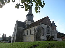
- Notre-Dame church with crossing tower, classified as a monument historique in 1930 .
- Cemetery with twelve wrought iron crosses, classified as a Monument historique in 1964.
- Mairie , a brick building from 1931.
Individual evidence
- ↑ Eglise in the Base Mérimée of the French Ministry of Culture (French)
- ↑ Cimetière in the Base Mérimée of the French Ministry of Culture (French)
Web links
Commons : Fontenay-Torcy - collection of images, videos and audio files

