Flavacourt
| Flavacourt | ||
|---|---|---|

|
|
|
| region | Hauts-de-France | |
| Department | Oise | |
| Arrondissement | Beauvais | |
| Canton | Beauvais-2 | |
| Community association | Pays de Bray | |
| Coordinates | 49 ° 20 ′ N , 1 ° 49 ′ E | |
| height | 82-187 m | |
| surface | 18.51 km 2 | |
| Residents | 659 (January 1, 2017) | |
| Population density | 36 inhabitants / km 2 | |
| Post Code | 60590 | |
| INSEE code | 60235 | |
 Flavacourt Town Hall |
||
Flavacourt is a French municipality with 659 inhabitants (at January 1, 2017) in Oise in the region of Hauts-de-France . The municipality is located in the arrondissement of Beauvais and is part of the Communauté de communes du Pays de Bray and des Beauvais-2 .
geography
The community on the D22 département road is about 7.5 kilometers north of Gisors and southeast of Sérifontaine . The southern part of the Forêt Domaniale de Thelle state forest belongs to it . It includes the hamlets of Lincourt, Le Petit Lincourt, La Folie, La Tremblée, Saint-Sulpice and Le Pré.
coat of arms
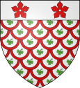
Description of the coat of arms : In the shield with a butterfly shield there is a silver shield head with two red five leaves .
Residents
| 1962 | 1968 | 1975 | 1982 | 1990 | 1999 | 2006 | 2011 |
|---|---|---|---|---|---|---|---|
| 439 | 393 | 368 | 435 | 572 | 699 | 708 | 689 |
administration
Mayor ( maire ) has been Xavier Hue since 2014.
Attractions
See also: List of Monuments historiques in Flavacourt
- Saint-Clair church with a mighty tower, classified as a monument historique in 1931
- Sainte-Anne chapel from the 13th century
- The Allée couverte du Bois de Champignolle in the Forêt de Thelle, about four kilometers northeast of Flavacourt.
literature
- M. Barré: Flavacourt, Notice historique et archéologique, Mémoires de la Société académique d'archéologie, sciences et arts du département de l'Oise, Imprimerie départementale de l'Oise, Beauvais, vol. 10 (1877), p. 765– 832.
Individual evidence
- ↑ http://clochers.org/Fichiers_HTML/Accueil/Accueil_clochers/60/accueil_60235.htm
- ↑ Église in the Base Mérimée of the French Ministry of Culture (French)
