Rotangy
| Rotangy | ||
|---|---|---|
|
|
||
| region | Hauts-de-France | |
| Department | Oise | |
| Arrondissement | Beauvais | |
| Canton | Saint-Just-en-Chaussée | |
| Community association | Beauvaisis | |
| Coordinates | 49 ° 35 ' N , 2 ° 5' E | |
| height | 134-179 m | |
| surface | 9.78 km 2 | |
| Residents | 213 (January 1, 2017) | |
| Population density | 22 inhabitants / km 2 | |
| Post Code | 60360 | |
| INSEE code | 60549 | |
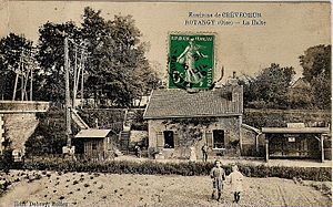
 The Rotangy stop, closed in 1939, around 1910 |
||
Rotangy is a French municipality with 213 inhabitants (at January 1, 2017) in Oise in the region of Hauts-de-France . The municipality is located in the arrondissement of Beauvais and is part of the Communauté d'agglomération du Beauvaisis and the canton of Saint-Just-en-Chaussée .
geography
The community, traversed by the tracks of the abandoned railway line from Amiens to Beauvais , is located on the watershed between the Somme and Seine on the plateau of the Picard plateau around four kilometers south of and immediately adjacent to Crèvecœur-le-Grand . There are several wind farms just outside the municipality.
Residents
| 1962 | 1968 | 1975 | 1982 | 1990 | 1999 | 2006 | 2011 |
|---|---|---|---|---|---|---|---|
| 212 | 186 | 166 | 170 | 166 | 195 | 199 | 200 |
administration
Mayor ( maire ) has been Régis Langlet since 2001.
Attractions
- Sainte-Marguerite Church
- Polydor Chapel in the cemetery outside the parish
Individual evidence
Web links
Commons : Rotangy - collection of images, videos and audio files
