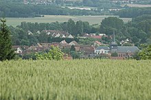
Saint-Aubin-en-Bray
| Saint-Aubin-en-Bray | ||
|---|---|---|
|
|
||
| region | Hauts-de-France | |
| Department | Oise | |
| Arrondissement | Beauvais | |
| Canton | Beauvais-2 | |
| Community association | Pays de Bray | |
| Coordinates | 49 ° 25 ' N , 1 ° 53' E | |
| height | 83-231 m | |
| surface | 6.38 km 2 | |
| Residents | 1,140 (January 1, 2017) | |
| Population density | 179 inhabitants / km 2 | |
| Post Code | 60650 | |
| INSEE code | 60567 | |
 The church |
||
Saint-Aubin-en-Bray is a French commune with 1,140 inhabitants (at January 1, 2017) in Oise in the region of Hauts-de-France . The municipality is located in the arrondissement of Beauvais and is part of the Communauté de communes du Pays de Bray and des Beauvais-2 .
geography
The municipality with the hamlet of Les Clérets extends from Avelon in the north via Route nationale 31 ( European route 46 ) with the hamlet of Les Fontainettes to the elevation level on which the neighboring municipalities of Le Coudray-Saint-Germer and Lalandelle are located.
history
The French King Charles VI. ceded the lands of the community to the Canon of Beauvais Arnaud Corbie in 1380 . Subsequently, they belonged to the Flavacourt House. The church was rebuilt in the 19th century.
Residents
| 1962 | 1968 | 1975 | 1982 | 1990 | 1999 | 2006 | 2011 |
|---|---|---|---|---|---|---|---|
| 690 | 744 | 825 | 835 | 855 | 904 | 1142 | 1002 |
administration
Mayor ( maire ) has been Michel Mayer since 2001.
Attractions
- Saint-Aubin church

