Cuigy-en-Bray
| Cuigy-en-Bray | ||
|---|---|---|
|
|
||
| region | Hauts-de-France | |
| Department | Oise | |
| Arrondissement | Beauvais | |
| Canton | Grandvilliers | |
| Community association | Pays de Bray | |
| Coordinates | 49 ° 26 ′ N , 1 ° 50 ′ E | |
| height | 96-226 m | |
| surface | 9.81 km 2 | |
| Residents | 943 (January 1, 2017) | |
| Population density | 96 inhabitants / km 2 | |
| Post Code | 60850 | |
| INSEE code | 60187 | |
| Website | http://www.cuigy.org/ | |
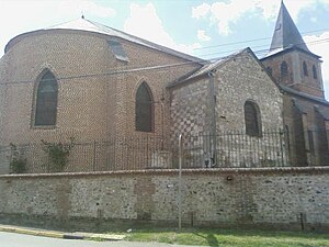
 Saint-Brice church |
||
Cuigy-en-Bray is a French commune with 943 inhabitants (at January 1, 2017) in Oise in the region of Hauts-de-France . The municipality is located in the arrondissement of Beauvais and is part of the Communauté de communes du Pays de Bray and the canton of Grandvilliers .
geography
The predominantly agricultural community is located between Saint-Germer-de-Fly and Le Coudray-Saint-Germer around 20 km west of Beauvais . Route nationale 31 ( Europastraße 46 ) runs through the northern municipal area , on which there are some smaller businesses. The municipality includes the hamlets of Saint Leu, Les Solons, Calimont, Les Eaux Ouies, Corleux and the houses of Les Larris on the slope that delimits the municipality to the south.
Toponymy
The place was first mentioned in 1015 as Cugiacum.
Residents
| 1962 | 1968 | 1975 | 1982 | 1990 | 1999 | 2006 | 2011 |
|---|---|---|---|---|---|---|---|
| 387 | 393 | 439 | 597 | 708 | 817 | 926 | 1055 |
administration
Mayor ( maire ) has been Bernard Noyelle since 2008.
Attractions
- Saint-Brice church
- Lourdes Chapel
Individual evidence
- ↑ http://clochers.org/Fichiers_HTML/Accueil/Accueil_clochers/60/accueil_60187.htm
- ↑ http://clochers.org/Fichiers_HTML/Accueil/Accueil_clochers/60/accueil_60187a.htm
