
Montreuil-sur-Thérain
| Montreuil-sur-Thérain | ||
|---|---|---|
|
||
| region | Hauts-de-France | |
| Department | Oise | |
| Arrondissement | Beauvais | |
| Canton | Chaumont-en-Vexin | |
| Community association | Thelloise | |
| Coordinates | 49 ° 23 ' N , 2 ° 12' E | |
| height | 50-147 m | |
| surface | 1.47 km 2 | |
| Residents | 245 (January 1, 2017) | |
| Population density | 167 inhabitants / km 2 | |
| Post Code | 60134 | |
| INSEE code | 60426 | |
 Town hall (mairie) |
||

Montreuil-sur-Thérain is a French municipality with 245 inhabitants (as of January 1 2017) in Oise in the region of Hauts-de-France . The municipality is located in the arrondissement of Beauvais and is part of the Communauté de communes Thelloise and the canton of Chaumont-en-Vexin .
geography
The municipality is located west of Thérain , whose valley is interspersed with ponds, on the railway line from Beauvais to Creil (with a stop on the border with Villers-Saint-Sépulcre), around ten kilometers north of Noailles .
history
The small municipality in terms of area was united with the neighboring municipality of Villers-Saint-Sépulcre from 1825 to 1835 .
Residents
| 1962 | 1968 | 1975 | 1982 | 1990 | 1999 | 2006 | 2011 |
|---|---|---|---|---|---|---|---|
| 77 | 100 | 89 | 115 | 145 | 182 | 220 | 245 |
administration
Mayor ( maire ) has been Alain Arnold since 2001.
Attractions
- One-aisle church Notre-Dame de l'Assomption from the first half of the 12th century, with a two-bay choir, on the first bay of which the bell tower rests (see also: List of Monuments historiques in Montreuil-sur-Thérain )
- Wayside shrine
- War memorial

Church of the Assumption of Mary

Wayside shrine
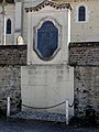
War memorial

Stop on the railway line from Beauvais to Creil

,_calvaire_au_carrefour.jpg)
,_monument_aux_morts_1.jpg)

Individual evidence
literature
- Dominique Vermand: Églises de l'Oise: Canton de Noailles, Pays de Bray, Pays de Thelle et Vallée de Thérain. Beauvais, n.d., p. 16.