Saint-Sulpice (Oise)
| Saint-Sulpice | ||
|---|---|---|
|
|
||
| region | Hauts-de-France | |
| Department | Oise | |
| Arrondissement | Beauvais | |
| Canton | Chaumont-en-Vexin | |
| Community association | Thelloise | |
| Coordinates | 49 ° 21 ' N , 2 ° 8' E | |
| height | 84-170 m | |
| surface | 8.88 km 2 | |
| Residents | 1,020 (January 1, 2017) | |
| Population density | 115 inhabitants / km 2 | |
| Post Code | 60430 | |
| INSEE code | 60598 | |
| Website | http://www.saint-sulpice-oise.fr/ | |
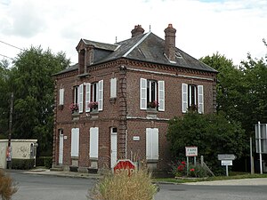
 Mairie Saint-Sulpice |
||
Saint-Sulpice is a French commune with 1,020 inhabitants (at January 1, 2017) in Oise in the region of Hauts-de-France . The municipality is located in the arrondissement of Beauvais and is part of the Communauté de communes Thelloise and the canton of Chaumont-en-Vexin .
geography
The community is located on the railway line from Paris to Beauvais and on to Le Tréport in the Pays de Thelle with the districts of Les Godins, Le Val de l'Eau, Le Bout de Brie, Troussencourt, Crécy, La Haute Ville and La Grosse Saulx seven kilometers west-northwest of Noailles . The municipality touches the A16 car route to the west . The Saint-Sulpice-Auteuil train station is located in the municipality.
Residents
| 1962 | 1968 | 1975 | 1982 | 1990 | 1999 | 2006 | 2011 |
|---|---|---|---|---|---|---|---|
| 588 | 549 | 613 | 650 | 886 | 951 | 940 | 940 |
administration
André Mélique has been mayor ( maire ) since 2008.
Attractions
- Saint-Sulpice church
- Castle of the Lords of Crécy, dating back to the 16th century, since 1968 the seat of the Maison Familiale Rurale de Saint-Sulpice
Individual evidence
Web links
Commons : Saint-Sulpice - collection of images, videos and audio files
- Monuments historiques (objects) in Saint-Sulpice (Oise) in the base Palissy of the French Ministry of Culture

