Le Vaumain
| Le Vaumain | ||
|---|---|---|
|
|
||
| region | Hauts-de-France | |
| Department | Oise | |
| Arrondissement | Beauvais | |
| Canton | Beauvais-2 | |
| Community association | Pays de Bray | |
| Coordinates | 49 ° 20 ′ N , 1 ° 52 ′ E | |
| height | 87-185 m | |
| surface | 8.1 km 2 | |
| Residents | 372 (January 1, 2017) | |
| Population density | 46 inhabitants / km 2 | |
| Post Code | 60590 | |
| INSEE code | 60660 | |
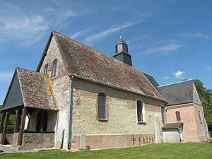
 Saint-Pierre church |
||
Le Vaumain is a French municipality with 372 inhabitants (at January 1, 2017) in the department of Oise in the region of Hauts-de-France . It belongs to the Arrondissement of Beauvais and the Canton of Beauvais-2 and to the Communauté de communes du Pays de Bray .
geography
The municipality with the hamlets of La Fonderie and Les Maisonettes is located around 16 kilometers southwest of Auneuil on the upper reaches of the Aunette river , which flows into the Seine via the Troësne and the Epte .
Residents
| 1962 | 1968 | 1975 | 1982 | 1990 | 1999 | 2006 | 2011 |
|---|---|---|---|---|---|---|---|
| 172 | 165 | 161 | 193 | 279 | 307 | 349 | 339 |
administration
Mayor ( maire ) has been Jean-Michel Duda since 2014.
Attractions
- Saint-Pierre church
- lock
literature
- M. Barré: Le Vaumain, Notice historique et archéologique, Mémoires de la Société académique d'archéologie, sciences et arts du département de l'Oise, Imprimerie départementale de l'Oise, Beauvais, vol. 9 (1874), p. 712 -749
Individual evidence
Web links
Commons : Le Vaumain - collection of images, videos and audio files
- Monuments historiques (objects) in Le Vaumain in the base Palissy of the French Ministry of Culture
