
Trie-Château
| Trie-Château | ||
|---|---|---|
.svg)
|
|
|
| region | Hauts-de-France | |
| Department | Oise | |
| Arrondissement | Beauvais | |
| Canton | Chaumont-en-Vexin | |
| Community association | Vexin Thelle | |
| Coordinates | 49 ° 17 ′ N , 1 ° 49 ′ E | |
| height | 52-146 m | |
| surface | 13.34 km 2 | |
| Residents | 1,943 (January 1, 2017) | |
| Population density | 146 inhabitants / km 2 | |
| Post Code | 60590 | |
| INSEE code | 60644 | |
 Château de Trie |
||

Trie-Château is a French commune with 1,943 inhabitants (as of January 1 2017) in the department of Oise in the region of Hauts-de-France . It belongs to the arrondissement of Beauvais and the canton of Chaumont-en-Vexin .
geography
Trie-Château is located in the Vexin at the confluence of the Aunette in the Troësne about three kilometers east of Gisors . The municipality is crossed by the railway line from Pontoise to Gournay-en-Bray . The districts of Les Kroumirs, La Folie and Le Moulin Tan belong to it . The station is south of the Troësne.
structure
| District | former INSEE code |
Area (km²) | Population (2016) |
|---|---|---|---|
| Trie-Château (administrative headquarters) | 60644 | 9.29 | 1,622 |
| Villers-sur-Trie | 60690 | 4.05 | 329 |
history
The community is located on an old Roman road that crosses the Troësne here .
In 1835 the smaller part of the municipality Trie-la-Ville became independent; the greater part of Trie then took the name Trie-Château. On January 1, 2018, the municipality of Villers-sur-Trie was incorporated.
Population development
| year | 1962 | 1968 | 1975 | 1982 | 1990 | 1999 | 2006 | 2011 |
|---|---|---|---|---|---|---|---|---|
| Residents | 815 | 957 | 1,052 | 1,357 | 1,412 | 1,460 | 1,515 | 1,503 |
Attractions
See also: List of Monuments historiques in Trie-Château
- Trie Castle, owned by the Dukes of Longueville , from 1694 by François Louis de Bourbon, prince de Conti ; was made available to Jean-Jacques Rousseau in 1767 ; Sold to Arthur de Gobineau in 1857
- Dolmen des Trois Pierres in the La Garenne district
- Sainte-Marie-Madeleine church
- City gate (15th century)
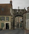
City gate
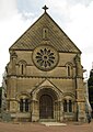
Sainte-Marie-Madeleine church


Personalities
- Antoinette von Orléans-Longueville (1572–1618), margravine and founder of the order
- Charles François Dupuis (1742–1809), French scholar, born in Trie-Château Antoinette of Orléans-Longueville
Web links
Individual evidence
- ↑ Population figures retrospectively from January 1, 2016