Lachaussée-du-Bois-d'Écu
| Lachaussée-du-Bois-d'Écu | ||
|---|---|---|
|
|
||
| region | Hauts-de-France | |
| Department | Oise | |
| Arrondissement | Beauvais | |
| Canton | Saint-Just-en-Chaussée | |
| Community association | Beauvaisis | |
| Coordinates | 49 ° 34 ' N , 2 ° 10' E | |
| height | 142-172 m | |
| surface | 5.92 km 2 | |
| Residents | 203 (January 1, 2017) | |
| Population density | 34 inhabitants / km 2 | |
| Post Code | 60480 | |
| INSEE code | 60336 | |
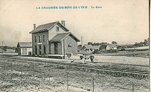
 The former train station (contemporary shot) |
||
Lachaussée-du-Bois-d'Écu is a French municipality with 203 inhabitants (at January 1, 2017) in Oise in the region of Hauts-de-France . The municipality is located in the arrondissement of Beauvais and is part of the Communauté d'agglomération du Beauvaisis and the canton of Saint-Just-en-Chaussée .
geography
The rural community is located on the D625 departmental road, which follows the course of a section of the Chaussée Brunehaut and the Roman road from Amiens to Beauvais , on the plateau of the Picard plateau around 10.5 km south-east of Crèvecœur-le-Grand and 3.5 km to the west by Froissy . In the east it extends beyond the A16 autoroute . From 1891 to 1939 (or 1953) a secondary railway, the meter-gauge railway from Estrées-Saint-Denis via Froissy to Crèvecœur-le-Grand, served the municipality.
history
The castle was destroyed in 1592.
Residents
| 1962 | 1968 | 1975 | 1982 | 1990 | 1999 | 2006 | 2011 |
|---|---|---|---|---|---|---|---|
| 167 | 157 | 148 | 139 | 144 | 166 | 192 | 213 |
administration
Mayor ( maire ) has been Bruno Gruel since 2008.
Attractions
- Church of Sainte-Restitude and Saint-Leu, rebuilt in 1829, with stained glass windows from the 16th century
Personalities
- Diogène Maillart (1840–1926), French painter, born here.
