Wartenberg (Eisenach)
| Wartenberg | ||
|---|---|---|
|
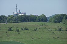
On the Wartenberg |
||
| height | 333.2 m above sea level NHN | |
| location | Thuringia ( Germany ) | |
| Mountains | Creuzburg – Eisenacher Graben , West Thuringian mountain and hill country | |
| Coordinates | 50 ° 59 '27 " N , 10 ° 19' 52" E | |
|
|
||
| rock | Shell limestone | |
| particularities | 240 ° panorama | |
The Wartenberg is 333.2 m above sea level. NHN high mountain in the north of the Wartburg city of Eisenach , in Thuringia .
topography
The Wartenberg is an east-west oriented mountain consisting of shell limestone, which borders the Eisenach basin at the Creuzburg – Eisenacher Graben to the north. Its eastern foothills are the Landgrafenberg ( 306.3 m above sea level ) and the Eichhölzchen. The boundary of the city of Eisenach runs over the Landgrafenberg. The upper southern slope of the Wartenberg is wooded, the route of the federal road B 19 runs over the central southern slope ; the north side is partly pastureland, partly wasteland (abandoned military area); the north-eastern part of the field belongs to the Eisenach industrial area Auf dem Wartenberg .
history
The field name Wartenberg refers to a high medieval lookout of the Eisenach city fortifications placed here .
Frohnishof desert
The western and northern part of the Landgrafenberg belonged to the district of Frohnishof until the middle of the 19th century , the buildings of this small settlement, as well as a homestead Kottenhof on the western slope of the Wartenberg were demolished and transferred to the district of Stregda.
The Wartburg Festival 1817
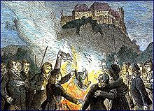
On October 18, 1817 , as part of the first Wartburg Festival on the summit, a nightly demonstration of progressive German students with incendiary speeches and a book burning at the stake took place, symbolically a Hessian military braid, an Austrian corporal cane , a Prussian Uhlan string and reactionary books in the blazing fire Fires were thrown.
The Eisenach Bismarck Tower
In place of the fraternity monument already planned here, the Eisenach Bismarck Tower was built on the Wartenberg in 1902 . A little below, the Bismarck Hut was built around 1910 by the Eisenach architects Gebrüder Kehl. A zoo was also created as an attraction of this popular excursion restaurant, which had a widely vaunted panoramic view. During the construction of the main road over the southern slope of the mountain, the city-side access to the Wartenberg was secured by an underpass.
Eisenach field airfield
During the First World War , a military field airfield was set up on the northeast slope of the Wartenberg and the Landgrafenberg to the east. During the Second World War , the Bismarck tower was used as an observation tower for aerial reconnaissance. It was badly damaged by shelling American planes.
Military area
In 1963 the ruined monument was blown up by order of the local authorities. At the same time, a military training ground for the Eisenach border regiment began on the northern slope of the Wartenberg, of which a watchtower, trenches and remains of bunkers can still be viewed. A transmitter mast was built on the highest point of the mountain; it was initially used for military purposes.
Civil transmitters
| program | Frequency (MHz) |
ERP (kW) |
|---|---|---|
| radio TOP 40 | 93.5 | 0.2 |
| Wartburg radio | 96.5 | 0.2 |
| MDR info | 100 | 0.2 |
| DLF | 106.5 | 0.5 |
To improve the TV reception quality in Eisenacher Südstadt, a filling station was put into operation on the Wartenberg in the 1970s . Another transmitter was (probably) used for radio traffic along the transit route on the A 4 federal motorway to West Berlin .
It is the location of a transmitter with a free-standing steel lattice tower and a small, architecturally interesting concrete tower, which was possibly originally built for a different purpose and is now used for mobile communications.
cards
- Topographic map 1:25 000: TK25 - sheet 4927 Creuzburg Thuringian Land Survey Office Erfurt 1992, ISBN 3-86140-202-5
- Topographic map 1:25 000: TK25 - sheet 5027 Eisenach Thuringian State Surveying Office, Erfurt 1994, ISBN 3-86140-047-2
Individual evidence
- ↑ Map services of the Federal Agency for Nature Conservation ( information )
- ↑ Official topographic maps of Thuringia 1: 10,000. Wartburgkreis, district of Gotha, district-free city of Eisenach . In: Thuringian Land Survey Office (Hrsg.): CD-ROM series Top10 . CD 2. Erfurt 1999.
- ^ Geography of the Grand Duchy of Saxony-Weimar-Eisenach. Part 2, edited by C. Kronfeld, Weimar, 1879, p. 54
- ^ Heinrich Weigel walks around Eisenach. Eisenacher Schriften zur Heimatkunde No. 7. Eisenach 1979 p. 69 f
- ↑ Max Kehl: Bergschänke Bismarckhütte with zoo on the Wartenberge below the Bismarck column near Eisenach . 1st edition. Artur Laue, Eisenach 1913, p. 24 .


