Sevlievo
| Sevlievo (Севлиево) | |||
|
|||
| Basic data | |||
|---|---|---|---|
| State : |
|
||
| Oblast : | Gabrovo | ||
| Residents : | 26,751 (December 31, 2011) | ||
| Coordinates : | 43 ° 2 ' N , 25 ° 6' E | ||
| Height : | 230 m | ||
| Postal code : | 5400 | ||
| Telephone code : | (+359) 0675 | ||
| License plate : | EB | ||
| administration | |||
| Mayor : | Jordan Stoikow | ||
| Website : | www.sevlievo.net | ||

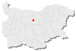
Sevlievo [ sɛvliɛvo ] (international Sevlievo , Bulgarian Севлиево ) is a town with 26,751 inhabitants (December 2011) in Central Bulgaria in Gabrovo Province . Sevlievo is 48 km north of Gabrovo and is the second largest city in Gabrovo Oblast after Gabrovo and the administrative center of the municipality of Sevlievo.
geography
Sevlievo is located in central northern Bulgaria, near the geographical center of Bulgaria. Nearby is the Balkan Mountains , the peaks of which reach up to 1900 m. The mountainous surroundings of the city have an average altitude of 400 to 700 m. The climate is moderately continental, with a large temperature fluctuation (+30 to +35 ° C in summer, −20 to −25 ° C in winter).
The Sevlievo municipality covers an area of 1070 km². Part of it is covered by tall deciduous forests, other parts by pastures and 42,000 hectares of arable land. There are significant water reserves because of the mountain range and the higher area in the south. This water catchment area is the headwaters of the rivers Rossiza (Bulgarian Росица) and Widima (Bulgarian Видима), which converge directly in front of the city and then fill one of the largest dams in Bulgaria, the reservoir Aleksandar Stambolijski (named after Aleksandar Stambolijski ).
In addition to the city of Sevlievo, there are 35 villages in the Sevlievo municipality. The municipality has a total of 39,537 inhabitants, of whom 24,065 live in the city of Sevlievo itself. The municipality has a comparatively well-developed road system with an average density of 0.416 km / km² and a total length of 391 km.
In the last decades Sevlievo has developed into a significant industrial center with well-developed agriculture and transport infrastructure. Industrial production is mainly concentrated in the city of Sevlievo.
Bigger companies in the city are the companies
- Ideal Standard Widima (Bulgarian Идеал Стандарт Видима) - water fittings:
- Ideal Standard Balgaria (bulg. Идеал Стандарт България) - household ceramics, glazes, enamels;
- Avangard (Bulgarian АВВ Авангард) - high-voltage electrical equipment (part of the Asea Brown Boveri concern ),
- Original (bulg. Оригинал) - press molds for pressure die casting with counter pressure;
- Emka (bulg. Емка) - electrical cables for industry and household;
- Rossitsa (bulg. Росица) - clothing;
- Bris (Bulgarian Бриз) - textile goods;
- Wood processing and furniture industry
- Batoj (Bulgarian Батой)
- Borela-S (Bulgarian Борела-С)
- Abanos (Bulgarian Abanos)
- Izgrev-90 (Bulgarian Изгрев-90)
- Paralel (Bulgarian Паралел)
The city is known for the Gamza wine made here.
Residents
| Sevlievo | ||||||||||
|---|---|---|---|---|---|---|---|---|---|---|
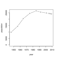
| year | 2005 | 2007 | 2009 | |||||||
| Residents | 24 448 | 24 258 | 24 065 | |||||||
| Sources: National Institute of Statistics | ||||||||||
Toponomics
According to Nikolaj Kowatschew, the metathesis of today's name Sevliewo developed as follows: From Сърбе / Сърби (pronounced Serbe / Serbi, possibly Srbe / Srbi), via Byzantine records to Серви (Serwi), via Arabic to Serfi (серфи) and Turkish to Selwi (селви). From this developed Selwiowo (Селвиово) and Sevliowo (Севлиово) and finally Sevliewo (Севлиево). The first name of the settlement Сърбе / Сърби, which Kowachev shows, transcribes Sarbe / Sarbi (alternatively Serbe / Serbi or Srbe / Srbi) and thus indicates an originally early settlement of Serbian settlers. The naming of a settlement, which is very likely to be traced back to the Serbian ethnicon, next to Malki Warschez , about 15 kilometers northwest of Sevlievo , whose official name was Сръбе / Сърбе (Srabe / Sarbe) until 1934, is no exception for this region.
history
Sevlievo, then Serbi or Serwi, emerged in the 10th century as the military and economic center of the First Bulgarian Empire in the area. The strong fortress Chotalich (Bulgarian Хоталич) was built on a hill protected from the environment, which is located 3 km northwest of the present city. Four districts, two churches, workshops for metal and ceramic processing within a fortified outer city. The city was quite large by medieval standards. Already in the 5th – 6th There was an early Byzantine fortress and settlement here, which was restored in the 10th century.
The fortress protected the entrance to the capital of the Second Bulgarian Empire Veliko Tarnovo .
The fortress was destroyed when the Turkish Ottomans took the area at the end of the 14th century. The city continued to exist until the end of the 18th century. The economic and administrative functions gradually passed to the village of Serwi or Selwi (Bulgarian Селви), which was newly settled by the Turks, from which today's Sevlievo developed.
The name Selwi was first mentioned in an Ottoman tax register in the 16th century, at that time also under the Hellenized name Serwi (Bulgarian Серви) or Chotalitsch (Bulgarian Хоталич). In addition to Gabrovo, Sevlievo was the second judicial district in the area - Kaza (see Sanjak ). The name Chotalitsch disappeared a few decades before the end of Ottoman rule over Bulgaria ( Russo-Turkish War, 1877–1878 ). It has not yet been clarified whether Chotalitsch was identical to the fortress or whether it was a separate village.
Since the end of the 17th century it was not just a simple village, but also a kadilak (bulg. Кадилък), d. H. a seat of the judge ( Qādī , also Kadi). The expansion of the Kadilak (legal district) mostly coincided with the Kaza (tax district).
Sevlievo with its fortress was on the way from Veliko Tarnovo to Lovech .
From 1860 Sevlievo became one of the centers of the organized movement of the national liberation of Bulgaria ( Bulgarian Revival ). Wassil Lewski created the first revolutionary committee here in 1870. As part of the April uprising , the population of the villages around Sevlievo rose up under the leadership of the city's revolutionary committee and fought for 10 days. Over 300 men, women and children were killed. Four of the large villages and numerous smaller villages were devastated. Eight of the leaders of the uprising were hanged in the city's central square. A memorial was erected here in 1894 to commemorate them (see photo).
Attractions
- Batoshevsky Monastery (bulg. Батошевски манастир)
Town twinning
-
 Babruysk , Belarus
 -
 Biel / Bienne , Switzerland
 -
 Valašské Meziříčí , Czech Republic
 -
 Gevgelija , Macedonia
 -
 Legionowo , Poland
sons and daughters of the town
- Fani Popowa-Mutafowa (1902–1977), writer
- Ilchan Kjuchjuk (* 1985), politician
Web links
Individual evidence
- ↑ a b c National Institute for Statistics ( Memento from November 13, 2013 in the Internet Archive )
- ↑ National Institute for Statistics ( Memento of November 13, 2013 in the Internet Archive )
- ↑ Местните названия от Севлиевско by Nikolaj Kowatschew (Николай Ковачев), 1961, p. 92, publisher Bulgarian Academy of Sciences
- ↑ Nikolaj Mitschew / Petar Koledarow: "Речник на селищата и селищните имена в България 1878–1987", Sofia, 1989
- ↑ http://www.hotalich-sevlievo.hit.bg/new_page_1.htm ( Memento from June 15, 2010 in the Internet Archive )


