Singerbach
| Singerbach | ||
|
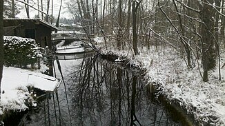
Singerbach near the confluence with the Starnberger See |
||
| Data | ||
| Water code | DE : 164614 | |
| location | Upper Bavaria | |
| River system | Danube | |
| Drain over | Starnberger See → Würm → Amper → Isar → Danube → Black Sea | |
| source | in the remote area Z- 47 ° 47 '18 " N , 11 ° 22' 30" O |
|
| Source height | 618 m above sea level NHN | |
| muzzle | in Lake Starnberg near Sankt Heinrich Coordinates: 47 ° 49 ′ 19 ″ N , 11 ° 19 ′ 55 ″ E 47 ° 49 ′ 19 ″ N , 11 ° 19 ′ 55 ″ E |
|
| Mouth height | 584 m above sea level NHN | |
| Height difference | 34 m | |
| Bottom slope | 4.2 ‰ | |
| length | 8.1 km | |
| Catchment area | 9.09 km² | |
The Singerbach in Upper Bavaria is a tributary to Lake Starnberg on its southeast side.
The inflow furthest from the mouth is near the Eitzenberger Weiher , which, however, drain in an easterly direction to the Brünnlesbach . The Singerbach, on the other hand, flows largely in a north-easterly direction, crosses under the Federal Motorway 95 and then meanders over about 4 kilometers and forms the municipal boundary between Iffeldorf and Münsing , thus also the district boundary between Weilheim-Schongau and Bad Tölz-Wolfratshausen . This district boundary continues in the creek in the border between Seeshaupt and Münsing for almost a kilometer to the confluence from the southeast into the Starnberger See near Sankt Heinrich
At Schechen , in addition to the municipality and district boundary, it also forms the northeast boundary of the Osterseen nature reserve .
Web links
- The course of the Singerbach in the BayernAtlas
Individual evidence
- ↑ a b Directory of creek and river areas in Bavaria - Isar river area of the Bavarian State Office for the Environment, as of 2016 (PDF; 2.5 MB)
