Sinningen (Kirchberg)
|
Sinningen (Kirchberg)
Municipality Kirchberg an der Iller
|
|
|---|---|
| Coordinates: 48 ° 8 ′ 47 " N , 10 ° 5 ′ 44" E | |
| Height : | 531 m above sea level NN |
| Residents : | 500 (2011) |
| Incorporation : | January 1, 1972 |
| Postal code : | 88486 |
| Area code : | 07354 |
|
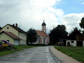
St. Michael Chapel (2012)
|
|
Sinningen is a district of the municipality of Kirchberg an der Iller in the Biberach district in Upper Swabia .
location
The church village is located at the northern end of the district, in the plain of the central Illertal . The Iller runs immediately to the east. The Gießen, an old arm of the Iller, flows through the place.
history
Presumably the village with the name ending in "-ingen" was founded by a settler named "Suno" after the Alemannic conquest. On the opposite side of the Illers are the remains of the late antique cohort fort Caelius Mons . The place was mentioned for the first time in 1127 as "Sunnigin" with the local nobility, which can be proven until 1172. In 1182 the place was called "Sunningin". Via the Lords of Heimertingen and later the House of Freyberg, it came to the Ulm mayor Ludwig Krafft in 1376 , and later in 1436 half to the Ehinger patrician family of Ulm.
The right of patronage has been exercised by the Rot an der Rot monastery since 1356 . In 1541, the Ulm Ehinger reformed the Unterbalzheim they owned and built a church in Oberbalzheim in 1608 . In 1611 the Red Abbot Joachim Gieteler tried to forbid the Sinningen subjects from visiting the Oberbalzheimer church. In 1616 the monastery was compared to the Ulmer Ehingern. The Ehinger committed themselves to lend their goods in Sinningen only to farmers of Catholic denomination.
The place was first mentioned as a municipality in 1578. In 1806 he was incorporated into the Kingdom of Württemberg together with Kirchberg . In 1835, Sinningen regained its communal independence after it had been part of Oberbalzheim until 1820.
The suburbs Sägmühle and values belonged to the community. On January 1, 1972, the municipality was incorporated into Kirchberg an der Iller as part of the municipal reform.
Economy and Infrastructure
In terms of its economic structure, Sinningen is characterized by agriculture. A small sawmill , a logging company and a nationally known campsite are also to be mentioned as larger commercial operations. A nationally known parade takes place at irregular intervals during the carnival . The small place has its own Guggenmusik .
Facilities and structures
- Chapel of St. Michael , renovated by the Red Abbot Balthasar Held in 1598/1611
- Sinningen Castle , a castle mentioned in 1127, which has been abandoned today
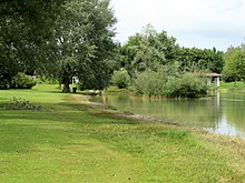
- Sinninger bathing lake with campsite; it was created in the 1970s / 80s through the extensive dismantling of Illerkies for the construction of the federal motorway 7 , section Ulm Oy - Mittelberg.
traffic
About 1.3 km east of the town center runs the A 7 motorway with the AS 125 slip road near Altenstadt . The state road L 260 from Memmingen to Ulm touches the place in the west.
politics
Mayor
Mayor of Sinningen:
- 1972–1986: Karl Schnurr, CDU
- 1986–1994: Alfons Ziegler, CDU
- 1994–2004: Christian Höß, SPD
- 2004–2009: Xaver Bühler, CDU
- since 2009: Friedrich Wohlhüter
coat of arms
In 1948 the place received a municipal coat of arms. It shows a shield divided by a wavy cut that refers to the Iller. The ball comes from the coat of arms of the Freyberg aristocratic family and the rafting hook refers to the Ehinger patrician family from Ulm.
literature
- Country descriptions of the Sigmaringen State Archive: The Biberach District Volume II . Ed .: Landesarchivdirektion Baden-Württemberg in connection with the district of Biberach. Jan Thorbecke Verlag, Sigmaringen 1990, ISBN 3-7995-6186-2 , p. 170-171 .
- Otto Beck: Art and history in the Biberach district. A travel guide to cultural sites and sights in the middle of Upper Swabia . 2nd Edition. Thorbecke, Sigmaringen 1985, ISBN 3-7995-3707-4 , p. 129
Web links
Individual evidence
- ↑ GenWiki Sinningen
- ^ Federal Statistical Office (ed.): Historical municipality directory for the Federal Republic of Germany. Name, border and key number changes in municipalities, counties and administrative districts from May 27, 1970 to December 31, 1982 . W. Kohlhammer, Stuttgart / Mainz 1983, ISBN 3-17-003263-1 , p. 525 .


