Soracachi
| Soracachi | ||
|---|---|---|
| Basic data | ||
| Residents (state) | 450 pop. (2012 census) | |
| height | 3792 m | |
| Post Code | 04-0104-0600-1001 | |
| Telephone code | (+591) | |
| Coordinates | 17 ° 46 ′ S , 67 ° 2 ′ W | |
|
|
||
| politics | ||
| Department | Oruro | |
| province | Province of Cercado | |
| climate | ||
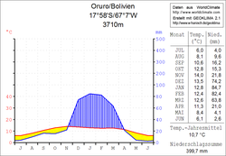
 Oruro climate diagram |
||
Soracachi is a town in the Oruro Department in the South American Andean state of Bolivia .
Location in the vicinity
Soracachi is the central place of the district ( Bolivian : Municipio ) Paria in the province of Cercado . The village lies at an altitude of 3792 m on the right bank of the southwest flowing stream of the Millu Punku , which seeps into the plain of the Río Caracollo between Caracollo and Oruro .
geography
Soracachi is located on the eastern edge of the Bolivian Altiplano in front of the Serranía de Sicasica ridge . The climate is characterized by a typical daytime climate , in which the temperature fluctuations between day and night are greater than between the seasons.
The annual average temperature of the region is around 10 ° C (see climate diagram Oruro), with the monthly average values fluctuating between 6 ° C in June / July and 14 ° C in November. The annual precipitation is a low 400 mm, with a pronounced dry season from April to November with monthly values below 20 mm, and a short humidity period from December to February with about 80 mm per month.
Transport network
Soracachi lies at a distance of 37 kilometers by road northeast of Oruro , the capital of the department.
The asphalted highway Ruta 12 leads through Soracachi, which begins at the village of Caihuasi , which is eleven kilometers to the north and leads first in a southerly direction, then from Oruro in a southwestern direction via Challacollo , Ancaravi , Huachacalla and Sabaya to Pisiga Bolívar on the Chilean border.
The northern end point of Ruta 12 meets at Caihuasi on the highway Ruta 4 , which with a length of 1,657 kilometers crosses Bolivia completely from west to east, from the Cordillera Occidental on the Chilean border to the lowlands on the Brazilian border. The road crosses the departments of Oruro , La Paz , Cochabamba and Santa Cruz . It begins in the west as a continuation of the Chilean Route 11 at Tambo Quemado and ends in the east in the city of Puerto Suárez , from where a detour of Route 4 leads to Puerto Busch .
population
The population of the village has increased only slightly in the past two decades:
| year | Residents | source |
|---|---|---|
| 1992 | 422 | census |
| 2001 | 480 | census |
| 2012 | 450 | census |
Due to the historically grown population distribution, the region has a significant proportion of Quechua population, in the municipality of Paria 93.1 percent of the population speak the Quechua language.
Individual evidence
- ^ INE - Instituto Nacional de Estadística Bolivia 1992
- ^ INE - Instituto Nacional de Estadística Bolivia 2001
- ↑ INE - Instituto Nacional de Estadística Bolivia 2012 ( Memento of the original from July 22, 2011 in the Internet Archive ) Info: The archive link has been inserted automatically and has not yet been checked. Please check the original and archive link according to the instructions and then remove this notice.
- ↑ INE social data Oruro 2001 (PDF; 6.2 MB)
Web links
- Municipio Paria - General Maps No. 40104
- Municipio Paria - detailed map and population data (PDF; 520 kB) ( Spanish )
- Departamento Oruro - Social data of the municipalities (PDF; 5.86 MB) ( Spanish )
