Southampton Water
| Southampton Water | ||
|---|---|---|
|
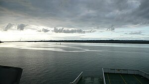
View over Southampton Water, Marchwood and Hythe in the background |
||
| Waters | Solent | |
| Land mass | Great Britain (island) | |
| Geographical location | 50 ° 51 ′ N , 1 ° 21 ′ W | |
|
|
||
| length | 15 km | |
The Southampton Water is a 15 kilometer long, narrow inlet on the south coast of England . It stretches from the Solent north of the Isle of Wight to the city of Southampton . The New Forest with the villages of Hythe and Fawley lie on the west bank lined with salt marshes . The eastern bank is slightly steeper; here are Weston (a suburb of Southampton), the villages of Netley and Hamble-le-Rice and the Royal Victoria Country Park .
Geographically, the Southampton Water is a ria of the English Channel , a river valley flooded by seawater. In this the rivers Test , Itchen and Hamble united . Towards the end of the last ice age , when sea levels rose, the valley was flooded.
Motorboat racing competitions were held here as part of the 1908 Summer Olympics .


