
Spechtensee
| Spechtensee | ||
|---|---|---|

|
||
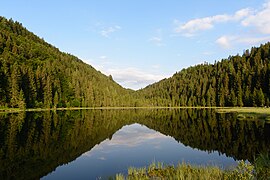
| Spechtensee towards the northeast | ||
| Geographical location | Dead Mountains , Styria , Austria | |
| Tributaries | Groundwater | |
| Drain | Wörschachbach | |
| Location close to the shore | Stainach , Pürgg , Bad Mitterndorf | |
| Data | ||
| Coordinates | 47 ° 33 '33.8 " N , 14 ° 5' 52.4" E | |
|
||
| Altitude above sea level | 1051 m above sea level A. | |
| surface | 3 ha | |
| length | 250 m | |
| width | 160 m | |
| scope | 700 m | |
| Maximum depth | 8-11 | |

The Spechtensee is a lake on the southern edge of the Dead Mountains near Wörschachwald in the municipality of Stainach-Pürgg , Styria.
location
The lake is located about three kilometers north of Stainach , four kilometers northeast of Pürgg , twelve kilometers east of Bad Mitterndorf , in the first transverse portal of the Dead Mountains to the Ennstal.
The lake is the Wörschachbach drained by the Wörschachklamm the Ennstal flows. The length of the lake is about 250 meters and its maximum width about 150 meters, the area about three hectares . It is a maximum of eight meters deep, according to other information, it is eleven meters deep.
History and use
The lake is probably named after the Specht family, who formerly lived in Stainach and lived on the Spechtengut (today Sonnhof Palace ) near Stainach until the end of the 19th century . Owning this property also included the lake. In 1843 the lake was still referred to in Georg Göth's Topography of the Duchy of Styria , Volume 3, as the “Fischersee” in the municipality of Zlem. It is not exactly known when the name “Spechtensee” finally became established.
The lake, which can be up to 23 degrees warm in summer, is also used as a bathing lake. There is a bathing area on the north bank and a small bathing island is anchored in the middle of the lake. The Spechtenseehütte of the Austrian Alpine Club is located near the lake .
Although the community no longer belongs to the Styrian Salzkammergut (Ausseerland – Salzkammergut region) , but rather to the Ennstal , the lake is mostly mentioned in the Salzkammergut lakes.

Panorama looking north
Looking west
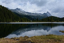
Looking east
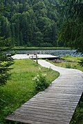
Bathing area


geology
The lake is located in worm-age moraines , which seal the lake from below and have created the hollow for the lake through their walls. In addition, there are conglomerates of the predominantly Cretaceous Gosau group around the lake .
Plant and animal world, nature conservation
On the east side of the lake there is a fen that merges with the swinging lawn into the open lake area. There is also a significant amount of vibrating lawn on the western side of the lake. The white water lily thrives in the southern lake area . Signal crabs are bred in the lake . The fish in the lake include brown trout and rainbow trout , as well as tench , rudd , roach , aitel and pike .
The lake is located in the Warscheneck Group landscape protection area ( LS15 ).
Web links
- Entry on Spechtensee in the Austria Forum (in the Heimatlexikon)
Individual evidence
- ↑ a b c d e Measured on the body of water, Digitaler Atlas Steiermark → Topic bodies of water & water information → Water → Body of water ; Expansion in the digital map (background) and the Austrian map ( official map ÖK) marked differently
- ↑ a b c d Martin Magnes: Spechtensee ( Memento of the original from June 17, 2011 in the Internet Archive ) Info: The archive link was inserted automatically and has not yet been checked. Please check the original and archive link according to the instructions and then remove this notice. ; Retrieved August 1, 2009.
- ↑ a b display board by the lake
- ↑ a b Geographical location of the Spechtensee ( memento of the original from July 20, 2010 in the Internet Archive ) Info: The archive link was inserted automatically and has not yet been checked. Please check the original and archive link according to the instructions and then remove this notice. , geomix.at
- ↑ North of the Grimming - Mühlbach - Wörschachbach - and further east, the second is the Tauplitz .
- ↑ Holidays in the Styrian Salzkammergut: Lakes with drinking water quality in the Ausseerland , bad-mitterndorf.at
- ↑ Geofast - Provisional Geological Map of the Republic of Austria 1: 50,000 , sheet 98, Liezen, Federal Geological Institute , as of October 2001.
- ↑ Fishing in the Spechtensee , steiermark.anglerinfo.at; Retrieved August 1, 2009.