
Speikboden (Zillertal Alps)
| Speikboden | |
|---|---|
 Speikboden from the northeast. On the right at the foot of the mountain the town of Luttach , behind it the Weißenbachtal . On the left at the foot of the mountain is Sand in Taufers , behind it Mühlen in Taufers and the Mühlwalder Valley |
|
| Highest peak | Speikboden ( 2517 m slm ) |
| location | South Tyrol / Italy |
| part of | Zillertal Alps |
| Coordinates | 46 ° 55 ' N , 11 ° 53' E |


The Speikboden is a mountain range in the Central Alps between Weißenbachtal , Mühlwalder Tal and Ahrntal . It represents the easternmost part of a foothill of the western Zillertal Alps , which extends roughly to the southeast . The highest point reaches a height of 2517 m and is also called Speikboden. Other named peaks of the massif are the Seewassernock ( 2516 m ), the Große Nock ( 2400 m ), the Kleine Nock ( 2227 m ) and the Gornerberg ( 2475 m ).
The valley locations include: Lappach, Luttach , Mühlwald , Sand in Taufers , St. Johann and Weißenbach .
Ski and hiking area
An extensive ski area of the same name extends on the Speikboden, with slopes as far as Third Sand in the outermost Ahrntal. Originally the ski area, which was built in the early 1970s by local investors and with Bavarian support (Bernhard Glück) and expanded several times, had the double name Michlreis-Speikboden (after the lower section of the resort).
The ski area is roughly divided into two sections. The first section is the valley run, which in turn consists of two sections. From the mountain station to the “Mitte” restaurant, you drive on an initially black, then red piste. From the “Mitte” restaurant, a black slope leads from Michlreis down to the valley. The entire valley run is 5.5 kilometers long.
In the upper section, a basin called the “Speikboden Alm”, you can ski on four red slopes, two blue and three black slopes, which can be reached with detachable chair lifts and cable cars . This upper section is a particularly suitable area for beginners and families, because there is a clear selection of well-groomed slopes. There are a total of 38 kilometers of slopes. At the valley station there is also a beginner's hill with two conveyor belts (magic carpets), on which the basics of skiing can be learned.
The lifts are also open in summer . The Speikboden has an extensive and very well-maintained network of trails. There are also two via ferratas (difficulty B / C and A).
Lift facilities
| Art | title | Delivery rate | length | Height difference |
|---|---|---|---|---|
| Cable car | Speikboden | 2,400 p / h | 2900 m | 1008 m |
| Detachable chairlift | Seenock | 2,400 p / h | 1200 m | 300 m |
| Detachable chairlift | Bernhard luck | 1,640 p / h | 1200 m | 360 m |
| Detachable chairlift | Very clear | 1,500 p / h | 900 m | 400 m |
| Cable car | Alm-Express | 2,400 p / h | 660 m | 150 m |
| Conveyor belt | Tottomandl | 1,000 p / h | 220 m | 40 m |
| Conveyor belt | Family fun park Toni | 1,000 p / h | 120 m | 21 m |
| Conveyor belt | Family fun park Leni | 1,000 p / h | 72 m | 12 m |
Snow park
At the edge of the Seenock piste there is a 400 meter long snow park with jumps and rails of all levels of difficulty.
Toboggan runs
Two toboggan runs start at the mountain station of the Speikboden cable car . One leads to Weißenbach , the other to Luttach , from where the free ski bus brings the toboggan riders back to the Speikboden valley station.
Paragliding, paragliding, hang gliding
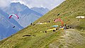
The Speikboden became known to cross-country pilots through Kurt Eder . The South Tyrolean rarely leaves his home country and is regularly on the podium in the XC world championship. This shows the potential of the area. The Speikboden is an excellent cross-country flight area for both beginners and experienced pilots , it can be flown all year round, but the best conditions are found from June to September. A wide panorama stretches from the starting points, in the south you can even see the central Dolomites . The Speikboden is just south of the Zillertal Alpine ridge . It is therefore poorly protected from the north wind; if it blows too hard, it is better not to fly. The high and imposing Durreck massif behind it protects the launch site from moderate north winds.
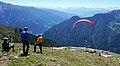
Take-off point for paragliders on Speikboden
Take-off point for paragliders on Speikboden

Paragliding on the Speikboden

Paragliding on the Speikboden

Paragliding on the Speikboden

Hang gliding on the Speikboden


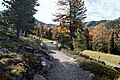
hike
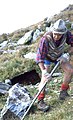
As early as the 1970s, the Speikboden began to be developed as a hiking area. The 1873 by Josef Daimer Founded section Tures of the German and Austrian Alpine Association built the shelter Sonklarhütte and related Steig "Herrenweg" (which was renamed in 1903 in honor of Josef Daimer in Daimerweg). The establishment of the Chemnitzer Hütte by the Chemnitz section of the German Alpine Club in 1895 was also thanks to the initiative and drive of Josef Daimer. In 1906 the high trail "Kellerbauerweg" was built to connect the two huts Sonklarhütte and Chemnitzer Hütte.
From the 1990s on, the Daimer- und Kellerbauerweg was used to improve and expand the network of paths. A process that continues to this day. There is now a network of paths over 90 kilometers long on Speikboden, which is maintained and expanded by the employees of the lift company.

Hiking map Speikboden (2019)

History of the Daimerweg

Road construction on Speikboden in the late 1990s and early 2000s
Road construction on Speikboden in the late 1990s and early 2000s

Road construction on Speikboden in the late 1990s and early 2000s
Hiking trails on the Speikboden

Hiking trails on the Speikboden

Hiking trails on the Speikboden
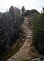
Hiking trails on the Speikboden

Hiking trails on the Speikboden


- Sonklarhütte
South of the summit at an altitude of 2420 m was the 1876 by the then section Tures of the German and Austrian Alpine Association erected and after Carl Sonklar named Sonklarhütte . The hut was built in just a few weeks and was one of the first huts in South Tyrol. At first it only offered 10 overnight stays, so that a larger hut had to be built as early as 1899. The hut was not operated during the First World War and fell into disrepair after the end of the war. A repair planned in 1926 by the new owner, the Bruneck Section of the CAI , was not implemented.
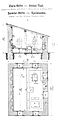
Design drawing of the Sonklarhütte by Johann Stüdl
Report inauguration Sonklarhütte

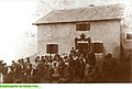
The Sonklarhütte on Speikboden - Josef Daimer

The Sonklarhütte Speikboden on an old postcard

Sign at the ruins of the Sonklarhütte Speikboden


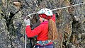
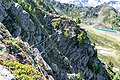
Via ferratas
Speikboden via ferrata
The via ferrata on Speikboden leads up to an average but demanding difficulty of 350 meters up to the Speikbodenkreuz at 2,517 m.
- Difficulty: B / C (moderately difficult)
- Start / finish: Speikboden Alm at 2,000 m, reachable with the Speikboden cable car
- Total ascent: 500 vertical meters | Walking time: 3 hours
- Ascent: 150 meters in altitude | Walking time: 40 min
- Return to the Speikboden Alm station:
- Via path no. 27 | Walking time approx. 1 hour 30 minutes
- Via Panoramaweg | Direction Sonnklarnock: 3 hours or direction Großer Nock: 2 hours
- With the Sonnklar | chairlift Walking time: 30 min
- Total time required: at least 4 hours
- Last descent of the Sonnklar chairlift: 4.30 p.m.
- Last descent of the Speikboden cable car: 5 p.m.
- Fuses: steel cable, clamps, rope bridge, suspension bridge
- Best season: June – October
- View: Dolomites, Rieserferner Group, Venediger Group, Zillertal Alps
- Equipment: climbing harness, via ferrata set, helmet, sturdy shoes (rental equipment available at the Speikboden Alm station)

Via ferrata
Via ferrata

Via ferrata
Via ferrata


Speikboden children's via ferrata
The children's via ferrata on Speikboden is specially designed for children between 6 and 12 years of age. Under the motto “Pirates”, the little ones can learn to climb on routes suitable for children.
- Difficulty: A (easy)
- Start / finish: Speikboden Alm station at 2000 m, accessible with the Speikboden cable car
- Ascent: 50 vertical meters, 20 min
- Ascent: 70 meters in altitude, 1 hour
- Total time required: at least 2 hours
- Equipment: Via ferrata set, helmet, sturdy shoes (rental equipment available at the Speikboden Alm station)
panorama


See also
Individual evidence
- ^ History of the section 1862 - 1900 - Alpine Association South Tyrol - Bozen - South Tyrol. Retrieved October 11, 2019 .
- ↑ Names of alpine huts: Daimer-Hütte, Zillertal Alps. Retrieved October 11, 2019 .
- ↑ History | DAV section Chemnitz:. Retrieved October 11, 2019 .
- ↑ http://www.kreiter.info/huetten/docs/sonklar-huette.htm
Web links
- Homepage of the Speikboden mountain railways
- 100 years of Kellerbauerweg and former Sonklarhütte (AVS section Sand in Taufers)
- Sonklar-Hütte in the historical Alpine archive of the Alpine clubs in Germany, Austria and South Tyrol (temporarily offline)