
Stauffenbergallee (Dresden)
| Stauffenbergallee | |
|---|---|
|
|
|
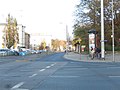
 Stauffenbergallee crossing Königsbrücker Straße , view towards the former garrison church |
|
| Basic data | |
| place | Dresden |
| District | Albertstadt |
| Created | 19th century |
| Hist. Names | Heerstraße, eastern part later Carola-Allee, the western König-Georg-Allee: GDR-time Dr.-Kurt-Fischer-Allee and since 1991 Stauffenbergallee |
| Confluent streets | Radeburger Strasse, Bundesstrasse B 170 , Pappelweg, Hammerweg, Zum Reiterberg, Rudolf-Leonhardt-Strasse, Buchenstrasse, Dammweg, Königsbrücker Strasse, Bundesstrasse B 97 , Hans-Oster-Strasse, Olbrichtplatz, Marienallee, Arno-Holz-Allee, Radeberger Strasse |
| Buildings | State Office for Road Construction and Transport , Dresden Police Headquarters, Dresden Nord Police Station, Hoxhold Craftsman, Riot Police, First Class Hotel Courtyard Dresden, MDR-Funkhaus Dresden , Military History Museum , Red Army Memorial , former Garrison Church, Prießnitz Bridge , Pioneer Monument , Fabrice Mausoleum , Count Stauffenberg - Barracks , state palaces, castles and gardens , State Directorate Saxony , Waldschlößchen tunnel. |
| use | |
| User groups | Pedestrian traffic , bicycle traffic , public transport , car traffic Local public transport |

The Stauffenbergallee is a street in Albert City in the north of Dresden and runs from the Radeburger road at Heller for Waldschlößchen (Radeberger road).
history
Around 1873
After the victorious Franco-Prussian War in 1871, what was then an ultra-modern barracks town was built in the northern part of the city on Dresdner Heller , Hellerberge and Junge Dresdner Heide under the supervision of the Saxon Minister of War Alfred von Fabrice . In the period from 1872 to 1873, a parade road, a 30-meter-wide and 3-kilometer long military road, was laid out. It reached from Hammerweg in the west to Radeberger Straße in the east, i.e. from St. Pauli cemetery to Waldschlößchen. The piece from Hammerweg to Radeburger Straße, the former Trainstraße, was built in the 1980s. The local train barracks, built from 1873 to 1879 for the 1st Royal Saxon Train Battalion No. 12, no longer exists. After the Waldschlößchen a natural obstacle, the Prießnitzgrund, had to be overcome. A 23 meter high arch bridge made of sandstone with three segment arches with a span of 15 meters was built between 1872 and 1873.
After 1945
The road and the bridge had lost much of their substance due to the military vehicles and the effects of the war and were temporarily restricted in use in 1958 and 1972 after severe storms. Only in the period from 2001 to 2003 was the bridge comprehensively repaired. In the middle of Stauffenbergallee it crosses Königsbrücker Straße. The western part of the intersection was named Prinz-Georg-Allee and the eastern part was named Carola-Allee. Numerous military buildings, barracks and guards were built from the Hammerweg to the Waldschlößchen. After the Second World War , the buildings were used by the Red Army . Bombed out Dresden residents, expellees and refugees had to look for other accommodations. In the 1950s, the Soviet military administration and the newly founded NVA as well as the forces of the riot police shared the area and the buildings. The name was changed to Nordallee in 1946. In 1950 the name was changed to Dr. Kurt-Fischer-Allee . After the peaceful revolution in 1989, the street was renamed in 1991 in honor of Colonel Claus Schenk Graf von Stauffenberg , who was shot dead . During the construction of the Waldschlößchenbrücke , the section between Radederger Straße and Königsbrücker Straße was completely renovated and renewed. On the other section between Königsbrücker Strasse and Radeburger Strasse, no maintenance work was carried out on the busy road. The existing pavement has been repaired and patched several times with bitumen asphalt. The sidewalks are overgrown and partially impassable, especially not usable for disabled people. On the section between Hammerweg and Radeburger Straße there is neither a walkway nor a bike path. Highest risk for such users, because there have already been several accidents, some of them resulting in death. The military buildings were converted into residential and office buildings and the residential buildings in the area facing Radeberger Strasse have also been renovated. In the other area to Radeburger Straße there is still a need for renovation. In the meantime, the railway bridge is also in need of renovation and is to be renewed in sections together with Stauffenbergallee. An S-Bahn stop is also to be created. A roundabout is planned at the Hammerweg intersection . A building application is to be submitted in 2020. However, you cannot rehabilitate this section of Stauffenbergallee without crossing Königsbrücker Straße.
Streets
Beginning at Radeburger Strasse, the federal road B 170, the confluence of Pappelweg follows in the direction of Radeburger Strasse, further east the Hammerweg crosses Stauffenbergallee. After an S-curve, the road to the Reiterberg follows inland. Then you will find the fragment of the Garde-Reiter monument at the Hechtpark. Coming towards the city, Rudolf-Leonhardt-Strasse and Buchenstrasse merge into Stauffenbergallee. Now it crosses under the railway bridge of the Görlitz-Dresden line (line 6212). After crossing under, the Dammweg joins the avenue towards the city. The Königsbrücker Straße, Bundesstraße B 97, crosses the Stauffenbergallee. After the intersection, Hans-Oster-Straße joins the city and turns into Olbrichtplatz. Next, the Prießnitzgrund is crossed and it crosses Marienallee. The confluence of the Arno-Holz-Allee follows the city. Another confluence takes place with the name Stauffenbergallee at the level of the regional office. At the Waldschlößchen tunnel, the Stauffenbergallee divides and ends at Radeberger Straße.
Local public transport
Coming from the Waldschlößchen, the bus routes of the Dresdner Verkehrsbetriebe 64 ( Kaditz - Reick ) and 74 (Marienallee-Jägerpark) operate the Stauffenbergallee. Tram lines 7 ( Pennrich - Weixdorf ) and 8 ( Südvorstadt - Hellerau ) run at the Königsbrücker Straße junction . Bus routes 70 ( Gompitz -Industriegebiet Nord) and 81 ( Wilschdorf -Bahnhof Neustadt) run on Radeburger Straße

Train barracks around 1898

Grenadier barracks regiment 101 around 1899

Stauffenbergallee junction Hammerweg 2019
Königsbrücker Strasse inland 2019

Olbrichtplatz 2019

Waldschlößchenbrücke tunnel, Radeberger Strasse
-Br%C3%BCck_%26_Sohn_Kunstverlag.jpg)


literature
- Dresdner Geschichtsverein eV: Dresdner Hefte: Dresden as a garrison town in Dresdner Hefte No. 53, 1/1998, 16th year, contributions to cultural history, 1998, general editor Hans-Peter Lühr, Sandstein-Verlag Dresden, ISBN 978-3-910055-94 -0 .
- Kay Haufe: Dresden's most annoying street, Sächsische Zeitung Dresden from October 26, 2019, page 16.
Web links
Individual evidence
- ↑ Kay Haufe: Dresden's most annoying street, Sächsische Zeitung Dresden, October 26, 2019, page 16
Coordinates: 51 ° 4 ′ 27.6 ″ N , 13 ° 45 ′ 45.1 ″ E