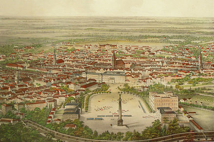
Steintorfeld (Hanover)

Colored steel engraving (detail) by Adolf Eltzner
The stone gate field of Hanover was a corridor outside the city fortifications . For centuries, the corridor stretched outside the former city limits in a semicircle northeast of the stone gate from the Chaussee to Celle ( Celler Strasse ) to the ship moat in the east near the New House to the (later) Aegidienneustadt .
The Steintorfeld is not to be confused with the Steintormasch , the Masch between the Leine and the Herrenhausen Gardens , for which the gardening director Julius Trip (not mentioned above) designed "Family Gardens in the Steintormasch".
history

Copper engraving around 1740 by IG Schmidt after EE Braun , from Christian Ulrich Grupens Origines Et Antiqvitates

A cross that already existed in Steintorfeld before the robbery murderer Jasper Hanebuth was turned in 1653 was later incorrectly assigned to the event, but then gave its name to the White Cross Square on the Lister Meile, which was named in 1929 .
As late as 1831, the stone gate field was outside the ramparts around the city, which were then redesigned to look like a park, and which were partly inhabited and used by the so-called gardeners . Since the ramparts were situated higher than the city area at that time and thus offered better protection against the floods in Hanover , the area seemed particularly suitable for city expansion: In 1820, 1825 and 1830 Georg Ludwig Friedrich Laves initially laid very extensive, then reduced Development plans before. But it was not until 1834 that Laves was formally commissioned to develop the stone gate field.
The formal building contract in 1834 marked the beginning of Lave's conception of the Ernst-August-Stadt between Georgstraße and the route of the railway construction decided in 1842 .
Around 1862 the stone gate field was limited to a small area north-east of the main station in the course of the advancing development .
Steintorfeldstrasse
Only the Steintorfeldstraße , laid out in 1860, still reminds of the formerly wide corridor. Around 1800 the street was still a garden path, which was named Kuhlmannswinkel from 1830 to 1860 .
literature
- Harold Hammer-Schenk : Notes on urban planning. In: From the castle to the train station. Building in Hanover. For the 200th birthday of the court architect GLF Laves , 1788–1864. An exhibition by the State of Lower Saxony, Institute for the History of Architecture and Art of the University of Hanover and the State Capital Hanover, Historical Museum , ed. by Harold Hammer-Schenk and Günther Kokkelink , exhibition in the forum of the Landesmuseum Hannover from October 13, 1988 to January 8, 1989, Institute for the History of Architecture and Art of the University of Hannover, Historisches Museum Hannover , 1988, ISBN 3-88746-223-8 , P. 241ff.
- Eva Benz-Rababah : Stone gate field. In: Klaus Mlynek, Waldemar R. Röhrbein (eds.) U. a .: City Lexicon Hanover . From the beginning to the present. Schlütersche, Hannover 2009, ISBN 978-3-89993-662-9 , p. 602.
Publicly owned maps
City maps of Hanover with the representation of the stone gate field are
- "Hanover, recorded and drawn in the years 1826 to 31 by August Papen ", around 1831, scale 1: 5000, copper engraving and etching , 69.5 cm × 77 cm (plate), 73.5 cm × 80.5 cm ( Blatt), etched by Papen, engraved by F. Nolle, Wild and Fischer , Verlag der Hornemann'schen Hof-Kunsthandlung , Hanover, in the possession of the Lower Saxony Main State Archives , archive number 12c Hann. 1.25 pg
Individual evidence
- ↑ a b c d Eva Benz-Rababah: Steintorfeld. In: Stadtlexikon Hannover , p. 602
- ↑ a b Harold Hammer-Schenk: Notes on urban planning ...
- ^ Eva Benz-Rababah: Allotments. In: Stadtlexikon Hannover , p. 351ff.
- ↑ Carl-Hans Hauptmeyer: 1653. In: Hannover Chronik , p. 52
- ^ Helmut Zimmermann : The street names of the state capital Hannover , Verlag Hahnsche Buchhandlung , Hannover 1992, ISBN 3-7752-6120-6 , p. 235.
Coordinates: 52 ° 22 ′ 54.7 " N , 9 ° 44 ′ 27.6" E