
Smelt catch


The Stintfang (historically also called Elbhöhe ) is a 26 meter high hill on the right bank of the Elbe in Hamburg . It is a remnant of the earlier Hamburg ramparts and, due to its exposed location above the St. Pauli Landungsbrücken, an important landmark in the Hamburg cityscape. The youth hostel on the Stintfang and the viewing platform in front of it with a view of the Port of Hamburg are particularly well known .
The name Stintfang is derived from the fish smelt and originally did not refer to the hill itself, but to the former moat that flowed into the Elbe to the west . According to tradition, large quantities of smelt were caught here every year in earlier centuries.
location
The Stintfang is located in the extreme southwest of Hamburg city center on the border with St. Pauli . In the north, the ridge goes over Seewartenstrasse into the Old Elbe Park with the Bismarck monument , to the west of it the Helgoländer Allee runs in the former moat. South of the Stintfang are the St. Pauli Landungsbrücken and in the east the so-called Portuguese Quarter in the southern part of Hamburg's Neustadt .
history

_--_2016_--_3171.jpg)

For the construction of the Hamburg ramparts between 1623 and 1629, a natural elevation was additionally heaped up and converted into the Albertus bastion , named after the Hamburg mayor Albrecht van Eitzen at the time. In the fortress, Albertus formed the most south-westerly of all the bastions where the moat was connected to the Elbe. To the west it was reinforced by a hornwork .
Between 1802 and 1811 there was a private observatory built by the entrepreneur and designer of optical instruments Johann Georg Repsold on today's Stintfang . It was demolished when the occupying forces began to restore the fortifications between 1811 and 1814 after the French had moved in and the main wall was completely restored.
After the French withdrew, the ramparts were finally razed and converted into parks. In 1869, the first international horticultural exhibition on German soil took place on the site of the former Albertus and Casparus bastions (by today's Bismarck monument) . The necessary redesign was planned by the horticultural entrepreneur Friedrich Jürgens , and the exhibition halls were designed by Martin Haller . In the following decades, the area was increasingly built on and the area was subdivided by the Kersten-Miles Bridge / Seewartenstrasse and the Helgoländer Allee , which is still visible today . After the Bismarck monument was erected in 1906, the part north of Seewartenstrasse was finally renamed Alter Elbpark , and the previously popular name Stintfang was finally adopted for the southern part.
In 1881 the representative office building of the Deutsche Seewarte , a predecessor of the German Hydrographic Institute, was built here . The four corner towers of the square building housed instruments for nautical and meteorological purposes and devices for their testing. During the Second World War, the naval observatory was destroyed in air raids on Hamburg .
Development
Youth hostel Auf dem Stintfang
After the end of the war there were initially plans to build a luxury hotel on the Stintfang. The then youth senator Paula Karpinski (1897-2005), however, persistently and ultimately successfully campaigned for the construction of a youth hostel . It was built on the foundations of the old sea observation point according to plans by Hermann Schöne and opened in 1953. When the idea for an extension of the neighboring Hotel Hafen Hamburg came up again in the late 1980s , Karpinski wrote to the mayor at the time, Henning Voscherau , demanding that the youth hostel be kept.
In the early 2000s the house was completely modernized. In 2013 the square in front of the youth hostel above the landing stages was named Paula-Karpinksi-Platz .
Vineyard on the Stintfang
Between 1995 and 2019 there was a small vineyard on the southern slope facing the Elbe , from where the harbor can be seen from afar. The vines planted there were a gift from the organizer of the Stuttgart Wine Village , which was a guest at the Hamburg Rathausmarkt every autumn from 1986 to 2015 . In 1995 they started with 50 vine plants, on the occasion of the 20th and 25th Stuttgart Wine Village in Hamburg, 25 more were added each time. Vines of the red wine variety Regent and the white wine variety Phoenix were grown on the smelt catcher . Every year 40 to 50 bottles of Hamburg Stintfang Cuvée were won there, which are exclusively given to guests of honor in the city. However, the 2010 vintage was canceled because the harvest was plundered by strangers. In 2016, 90% of the grapes were stolen again. All vines were cleared on February 24, 2019 due to construction work at the Landungsbrücken subway station and given away to interested parties.
Landungsbrücken underground station
At the foot of the Stintfang is the Landungsbrücken underground station on the ring line . It is in turn part of the St. Pauli-Landungsbrücken traffic junction.
Development on the eastern slope of the Stintfang
In February 2017, approval was given for a voluminous building complex with a fixed building height of 27.1 m above sea level - thus higher than the Stintfang itself - in the listed green area in the area of the historic Albertus bastion. Criticism of the building project is justified by the reduction of large parts of the eastern slope in its public area and, above all, with the severe impairment of the panoramic view from the Stintfang and the park paths of the eastern slope of the Neustadt and the harbor.
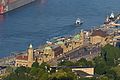
View over the Stintfang and the youth hostel to the landing stages and harbor

View from the youth hostel on the Stintfang to the harbor
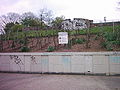
Former vine plantings on the Geest slope (2007)

Entrances to the Landungsbrücken underground station at the foot of the Stintfang


See also
Web links
Individual evidence
- ↑ Hamburger Abendblatt: "The stint is here!" ( Memento from January 18, 2016 in the Internet Archive )
- ↑ Polyglott Travel Guide Hamburg . Polyglott-Verlag Munich, 3rd edition 1971, p. 47.
- ↑ von Eitzen, Albrecht (1578-1653, Mayor 1623-1653) , deutsche-biographie.de (accessed on September 1, 2018)
- ↑ CF Gaedechens: Historical topography of the Free and Hanseatic City of Hamburg and its immediate surroundings from its origins to the present. Hamburg 1880.
- ^ W. Melhop: Historical topography of the Free and Hanseatic City of Hamburg 1895-1920. Hamburg 1923, pp. 199-201.
- ^ Jörg Schilling: The youth hostel / house of the youth on the Stintfang . In: Hamburger Bauhefte . tape 29 . Schaff-Verlag, Hamburg 2019, ISBN 978-3-944405-45-2 .
- ^ Weinberg am Stintfang - Germany's northernmost vineyard ( Memento from February 1, 2014 in the Internet Archive )
- ^ No more Stuttgart wine village in Hamburg. Stuttgarter Zeitung, January 13, 2017, accessed on July 3, 2017 .
- ↑ Mundraub am Stintfang - grape harvest is canceled. In: NDR.de from September 29, 2010. ( Memento from October 2, 2010 in the Internet Archive )
- ↑ We can no longer conjure up the grapes In: ZEIT Online, September 20, 2016.
- ↑ NDR: Hamburg is giving away its vines. Retrieved February 25, 2019 .
- ↑ Justification of the development plan, 5.1.1 Degree of structural use, page 26 (PDF file), accessed on December 31, 2017
- ↑ New construction of a residential and commercial building with an underground car park. Building permit procedure M / BP / 00127/2016 of February 22, 2017 , accessed on December 31, 2017
- ↑ Hamburg Monument Council: Statement on the planned development on Stintfang , December 6, 2013 , accessed on December 31, 2017
- ↑ Historian warns of new building at Stintfang , Abendblatt.de of August 31, 2013 , accessed on December 31, 2017
- ↑ The new building at Stintfang is on the brink again , evening paper of February 6, 2017 , accessed on December 31, 2017
- ↑ Green light for controversial new building on Stintfang , evening paper of February 10, 2017 , accessed on December 31, 2017
Coordinates: 53 ° 32 ′ 48 ″ N , 9 ° 58 ′ 20 ″ E