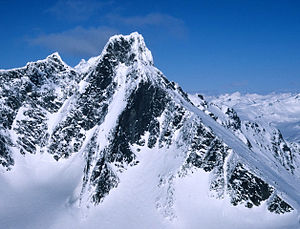
Store Skagastølstind
| Store Skagastølstind | ||
|---|---|---|
|
"Storen" seen from Dyrhaugsryggen |
||
| height | 2405 moh. | |
| location | Årdal , chandelier | |
| Mountains | Styggedals- og Skagastølsryggen ( Jotunheimen ) | |
| Dominance | 30 km → Galdhøpiggen | |
| Notch height | 1015 m ↓ | |
| Coordinates | 61 ° 27 ′ 41 ″ N , 7 ° 52 ′ 19 ″ E | |
|
|
||
| First ascent | July 21, 1876 (Slingsby) | |
| Normal way | Heftyes route | |
| particularities | third highest mountain in Norway | |
|
Skagastølstindane (blinds far right) |
||
The Store Skagastølstind , also briefly Storen ( German : the Great) is called, with its 2405 meters the third highest mountain in Norway and the highest in the Norwegian Vestlandet . It is part of the Styggedals- og Skagastølsryggen and forms the southernmost peak of the Skagastølstindane mountain range. It is located in the Hurrungane area , in the southwest of Jotunheimen . It lies on the border between the two municipalities of Luster and Årdal in the province of Vestland , and the summit marks one of the border points.
history
The Skagastølstind store is located a little south of the old path across Sognefjell and was known and described early on. A travelogue was written of the area in the 1820s describing the mountain's rugged appearance. At that time there was speculation as to whether it would be the highest mountain in Norway. Theodor Broch measured the mountain from the surrounding mountains in 1836. In 1842 Harald Nicolai Storm Wergeland surveyed the mountain again and announced that Galdhøpiggen was higher.
Until the beginning of the 1870s the mountain was considered impregnable and no attempt was made to climb it for the first time. The English mountaineer William Cecil Slingsby became aware of the mountain in 1872 while traveling through Norway. He returned to Norway in 1874 and 1875, both times with the aim of scaling the mountain. But due to the bad weather he broke off the tour.
In 1876 Slingsby traveled to Norway with Emanuel Mohn . They hired Knut Lykken from Valdres as a mountain guide. After a successful hike through the Jotunheimen Mountains, during which they completed many first ascents, they set off from Vormeli to Store Skagastølstind on July 21st . She had only climbed Gjertvasstind the day before , also as the first ascent. Since they after a grueling tour of the Midtmarnadalen and over the now Slingsbybreen called glacier wandering, it was just Slingsby, of the way of the gorge between the Store Skagastølstind and Vetle Skagastølstind continued. This gorge was named Mohns skar (German: Mohns Schlucht). The mountain was covered with ice, but he managed to climb the summit on his own. With this summit storm he undertook the largest climbing expedition in Norway to date.
After this performance, the attention around the mountain continued to grow. Now the Norwegians wanted their honor. The young art student Harald Pettersen accepted the challenge and climbed the summit in 1878, after a failed attempt the previous year, via the same route as Slingsby.
Johannes Heftye , son of Thomas Johannessen Heftye , had a heated public debate with Slingsby about the difficulties of climbing Store Skagastølstind compared to Knutsholstinden , which he had first climbed in 1875. In 1880 he wanted to prove that it was easy to climb Store Skagastølstind. He climbed the mountain with Jens Klingenberg and Peder Melheim from Årdal, but due to a mistake on the route they found an easier way to climb the mountain. This route is now considered to be the “normal” way to climb the summit.
The Skagastølstind store later remained important to Norway's mountaineering history. The first ascent via the south path from Slingsbybreen, which turns east, opened up a long and complicated route. It was explored in 1927 by Ola H. Furuseth, Asbjørn Gunneng and Boye Schlytter. This route is considered a milestone for alpine climbing introduced by Arne Næss ten years later in Norway.
In 1976, Ulf Geir Hansen and Hans Petter Fernander explored the route over the west face and set new standards for climbing in the Jotunheimen high mountains.
Routes to the summit
There are several routes to the summit. The most important are:
- Slingsby's route
- Heftyes route
- Andrews route
- Northwest Way
- South way
- West ridge
- Westweg
See also
literature
- Klatrefører for Jotunheimen, NTK, 1996.
- Ben Johnsen: Jotunheimens stortopper: folk og fjell gjennom tidene , NTK. Pp. 99-101. ISBN 978-82-992317-0-1 . English guidebook to Store Skagastølstind
- Cecil Slingsby; Tony Howard, Tony: Norway: the Northern Playground , Rockbuy Limited. 2003, ISBN 978-1-904466-07-9 . Slingsby's story of the first ascent of Skagastølstind in 1876
Web links
- Store Skagastølstind. In: Store norske leksikon . Retrieved September 19, 2013 (Norwegian).
- Blind on westcoastpeaks.com
- Video from store Skagastølstind
Individual evidence
- ↑ There are 2 possible reference points between Prestesteinsvatnet and Utla : 1st island between Kista and Nedre Steinsdalsvatnet and 2nd gorge southeast of Rundhaugstjønne. Both saddle points are between 1380 and 1400 moh. so that the saddle height can be assumed to be 1390 moh in both cases .
- ↑ faktaark.statkart.no , accessed on September 19, 2013 (Norwegian)


