Strelln
|
Strelln
community Mockrehna
Coordinates: 51 ° 28 ′ 53 " N , 12 ° 46 ′ 45" E
|
||
|---|---|---|
| Height : | 110 m | |
| Area : | 89 ha | |
| Residents : | 452 (Jan 5, 2010) | |
| Population density : | 508 inhabitants / km² | |
| Incorporation : | January 1, 1999 | |
| Postal code : | 04862 | |
| Area code : | 034244 | |
|
Location of Strelln in Saxony |
||
Strelln is a district of the municipality Mockrehna in the district of Northern Saxony (Saxony).
geography
Strelln is east of the city of Eilenburg and southwest of the main town of Mockrehna on the district roads 8903 and 8907. North of the town are the federal road 87 and the Halle – Cottbus railway line . The next train station is Doberschütz . The place is in the Paschwitz-Mockrehna valley ; The Wurzen porphyry hill country begins south of the village . The highest elevation in the district is the Strellnsche Berg at 131 meters above sea level . To the north of Strelln is the area of the Eilenburger Ratsforst with an ammunition store for the Bundeswehr . Of the total area of 888 hectares, 40 hectares are forested. In the corridor of Strelln There is also the Ortswüstung Rochlitz. The type of settlement is a street village with a square village part .
In the district Strelln are sandy soil , clay and Tieflehm and to a lesser extent Auenlehm and Auendecklehm to be found.
The average annual rainfall is 540 mm. The annual average temperature is between eight and nine degrees Celsius.
history
Strelln existed as an independent municipality until 1999 when it merged with Audenhain , Schöna , Wildenhain , Wildschütz and Mockrehna to form the current municipality of Mockrehna. Most of the current building stock dates from around 1890 to 1940. Most of these are three-sided courtyards .
Population development
| year | Residents |
|---|---|
| 1818 | 240 |
| 1880 | 428 |
| 1895 | 433 |
| 1910 | 497 |
| 1925 | 514 |
| year | Residents |
|---|---|
| 1939 | 592 |
| 1946 | 817 |
| 1950 | 749 |
| 1964 | 613 |
| 1990 | 539 |
| 2010 | 452 |
The population of the place was at the beginning of the 19th century with 240. In the following decades there was a continuous growth of the population, which culminated in 1946 with a number of 817. This all-time high is due to the influx of refugees from the former German eastern regions after the Second World War. During the GDR era, the number of inhabitants decreased noticeably, so that in 1990 there were still 539 people living in the village. After the reunification, this trend continued, until 2010 the place lost around 100 inhabitants.
Village church
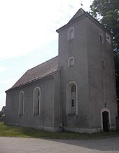
The baroque village church from the 18th century is located in the northern part of the village at the end of a cul-de-sac. A previous building from the 12th century is suspected to be at the same location. The church consists of the hall to which the tower adjoins to the west . The church's masonry altar from the time the church was built has a wooden pulpit with columns, pulpit and sound cover . The church has two bells, one of which is from the late Gothic period. The former cemetery adjoins the south side of the church.
Web links
- Strelln in the Digital Historical Directory of Saxony
- Strelln on the website of the municipality of Mockrehna

