
Svatá Anna (Oslov)
| Svatá Anna | |||||
|---|---|---|---|---|---|
|
|||||
| Basic data | |||||
| State : |
|
||||
| Region : | Jihočeský kraj | ||||
| District : | Písek | ||||
| Municipality : | Oslov | ||||
| Geographic location : | 49 ° 25 ' N , 14 ° 11' E | ||||
| Height: | 371 m nm | ||||
| Residents : | 3 (March 1, 2001) | ||||
| Postal code : | 398 18 | ||||
| License plate : | C. | ||||
| traffic | |||||
| Street: | no | ||||
| Next international airport : | České Budějovice Airport | ||||


Svatá Anna (German St. Anna ) is a district of the municipality Oslov in the Czech Republic . It is located 13 kilometers north of Písek and belongs to the Okres Písek .
geography
Svatá Anna is located in the Central Bohemian hill country on the right side of the confluence of the Strouha brook in the Otava on a headland in the Orlík reservoir . The Lomnice flows into the Otava south of Svatá Anna . The forest of Červený les stretches to the northeast, while the Dejmov pond lies to the east. The state road II / 138 runs east of the village between Zvíkovské Podhradí and Oslov, from which a road leads to Svatá Anna at Dejmov.
Neighboring places are Na Budách, Kopanina, Zbonín and Zvíkov in the north, Zvíkovské Podhradí , Bohuslavský, Kučeř , U Moravců, U Kloboučníků and V Dolanech in the northeast, Dejmov, Květov , Pazderna, Dolnervice and Vůsí , Zbároví in the east, Strourov . díl and Oslov in the south-east, Pazderny, Tukleky and U Chyšáků in the south, Dědovice, Doupata and U Štědronských in the south-west, Štědronín in the west and Varvažov and Varvažovská Paseka in the north-west.
history
In the first half of the 16th century there was a hermitage on the steep rocky spur of a bend in the river Otava over the St. Anna rapids ( Anenské proudy ). In the years 1545–1548, the owner of the Klingenberg estate , Heinrich von Schwanberg, had the chapel of St. John in its place for 81 shock groschen. Erect Anna.
In 1574, Christoph von Schwanberg combined the Klingenberg estate with the Worlik estate he had acquired three years earlier and bought Klingenberg the following year as hereditary property. After the battle of the White Mountain , the estate of Peter von Schwanberg was confiscated and in 1622 the Eggenberg owners of the Worlik and Klingenberg estate. After the male line of Eggenberg died out in 1717, the Schwarzenberg family inherited their property. After Annentag , an annual St. Anne pilgrimage has been held since the 18th century.
In 1837 St. Anna consisted of 7 houses with 65 inhabitants. On the high rocky bank stood the public chapel of St. Anna. Traces of former gold panning were found in the Wottawa valley . The parish was Voslow . Until the middle of the 19th century, St. Anna remained subordinate to the Fideikommissherrschaft Worlik, including the allodial goods Zalužan, Zbenitz and Bukowan, as part of the Klingenberg domain.
After the abolition of patrimonial formed Svatá Anna / Sanct Anna from 1850 a district of the municipality Podhradí in the district administration and the judicial district Písek Mirovice. The village consisted of nine thatched chalets. The residents were forest workers and raftsmen. Since no arable farming was possible on the rocky spur, the Chalupners cultivate small fields by hand on the left bank of the Otava below the Hřebínek slope in Kopaniny. Because of the steep slope, these were not accessible by carts, so the harvest had to be brought to Svatá Anna in carrying baskets, and the manure was carried down to fertilize in the same way. The drinking water also had to be fetched from the valley with wooden butts. Two barge crossings were later built over the Otava.
During the German War , after the Battle of Königgrätz, a Prussian army under the command of Eberhard Herwarth von Bittenfeld occupied the area for several days on August 10, 1866 with 60,000 infantrymen and 12,000 cavalrymen. The infantry camped across from Svatá Anna in the area of today's Jitex recreation center near Štědronín. The Prussians set up their headquarters in Worlik Castle .
As a result of the population's interest in the historical sites of the region since the end of the 19th century, the československých turistů club in honor of August Sedláček built the 25 km long Sedláček along the Otava between the Zvíkov and Písek castles between 1924 and 1928. Create a path ( Sedláčkova stezka ) that was led around the bend on the left with a view of Svatá Anna. Svatá Anna and Oslov broke away from Zvíkovské Podhradí in 1928 and formed the municipality of Oslov .
Between 1956 and 1963 the Orlík dam was built with which the settlements of Cukava, Mošovice, U Urycha and U Vlků in the Otava Valley were flooded. With the rise of the water level by 35 m, the rapids of the Otava between the Lomnice estuary and Svatá Anna and the lower section of the Sedláček path sank in the reservoir; Some parts of this are still visible on the rocks opposite.
In 1991 Svatá Anna had two inhabitants, at the 2001 census three people lived in the seven houses.
Local division
Svatá Anna is part of the Oslov cadastral district. The Dejmov and Strouha strata also belong to the district.
Attractions
- Late Gothic Chapel of St. Anna, built 1545–1548. The baroque altarpiece of the saint dates from the 1st half of the 18th century.
- Krkavčina nature reserve , rocky slope at the bend of the Otava, south of Svatá Anna
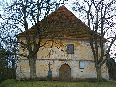
Chapel of St. Anna

Krkavčina nature reserve

.JPG)
Legends
The chapel of St. Anna is the subject of several legends. The chapel is said to be the exit of a secret passage from Zvíkov Castle. A great treasure is said to be buried in the chapel, which only came to light at a time when Bohemia was on the verge of ruin. It is said to have been dug around 1806 and only an empty box was found. In addition, the grave of an unknown youth is said to be on the south side of the altar.
Web links
Individual evidence
- ^ A b Johann Gottfried Sommer : The Kingdom of Böhmen, Bd. 8 Prachiner Kreis , 1840, p. 64